Originally surveyed as Township No. 3 in the 1st Range North of the Plymouth Claim
East of the Kennebec River as part of the Province of Maine of Massachusetts Bay Colony
Known as Warrens No. 3 – Organized October 11, 1819 as a Plantation
Incorporated February 7, 1820 as Town of Hartland, Somerset County, District of Maine, Commonwealth of Massachusetts
*
Maps provide invaluable historical insight into the transition of Hartland from an unsettled area of land in the wilderness to a thriving community. Maps are not without their flaws and do occasionally contain certain minor inaccuracies or geographical landmark omissions. However, in lieu of the ways and means available at the time many of these early surveys were conducted then transferred into printed maps, they are remarkably accurate overall.
*
The history of the Plymouth Claim, aka Plymouth Patent or Kennebec Patent, and its respective proprietors, holdings, sales and settlement is a long, complicated and often controversial story. Numerous other sources cover its history in detail and only a general compilation of information directly relating to Hartland is presented below.
*
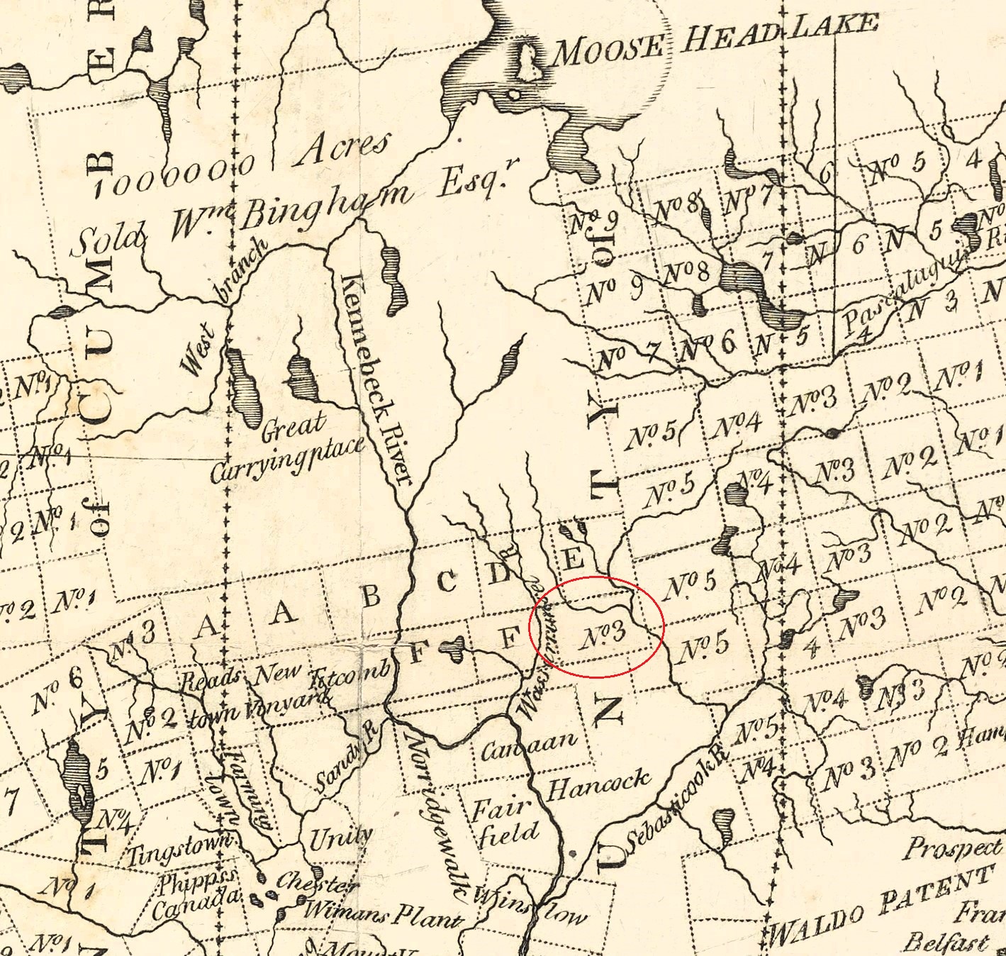
One of the first known maps to include some of the townships in the previously unsettled wilderness region north of the Waldo Patent and the Plymouth Claim in the then Province of Maine was surveyed by Ephraim Ballard in September of 1779. Ballard (1725-1821) came from Massachusetts to Hallowell (part of future Augusta) in 1775 and was joined there by his family in 1777. He produced numerous maps in the area as one of the principal surveyors for the Kennebec Proprietors, a group of heirs officially known as “The Proprietors of Kennebeck Purchase from the late Colony of New Plymouth” which had organized in 1749 to lay claim to the original 1629 Plymouth Land Patent which was awarded to them by the General Court of Massachusetts in 1753. This “new” land patent would be interchangeably referred to as either the Kennebec Patent, Plymouth Patent or the Plymouth Claim; the latter used for this compilation. Following the end of the Revolutionary War, great interest was taken in unclaimed lands across Maine by the Lands Committee who were appointed by the General Court of Massachusetts with full power and authority to sell and convey unappropriated lands of the Commonwealth lying within Maine.
Ephraim Ballard married Martha Moore (1735-1812) who served as a healer and as a midwife to hundreds of births in the Hallowell area and kept a diary with thousands of entries over nearly three decades. She was made famous by the publication of “A Midwife’s Tale: The Life of Martha Ballard based on her diary, 1785–1812” by historian Laurel Thatcher Ulrich in 1990.
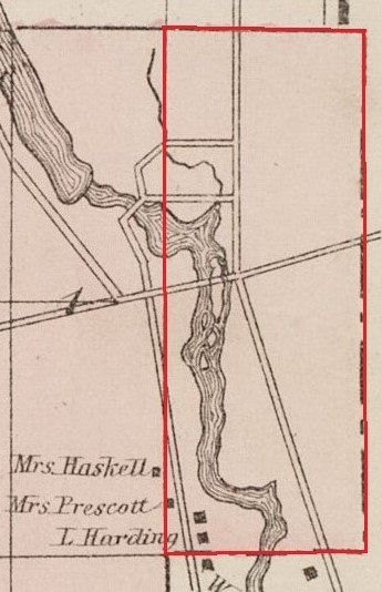
As noted on the original map, Ballard’s survey focused primarily on boundary lines of four townships north of the Waldo Patent including Township No. 5 in the Third Range including the L (Palmyra) and Township No. 5 in the Fourth Range (St Albans). He did however include a partial notation for Township No. 3 in the First Range north of the Plymouth Claim which eventually became Hartland. The map included placement of part of Moose Pond, its Main Stream inlet, its outlet as the West Branch of the Sebasticook River and the river’s confluence with Indian Stream as seen on this close-up crop of the original map.
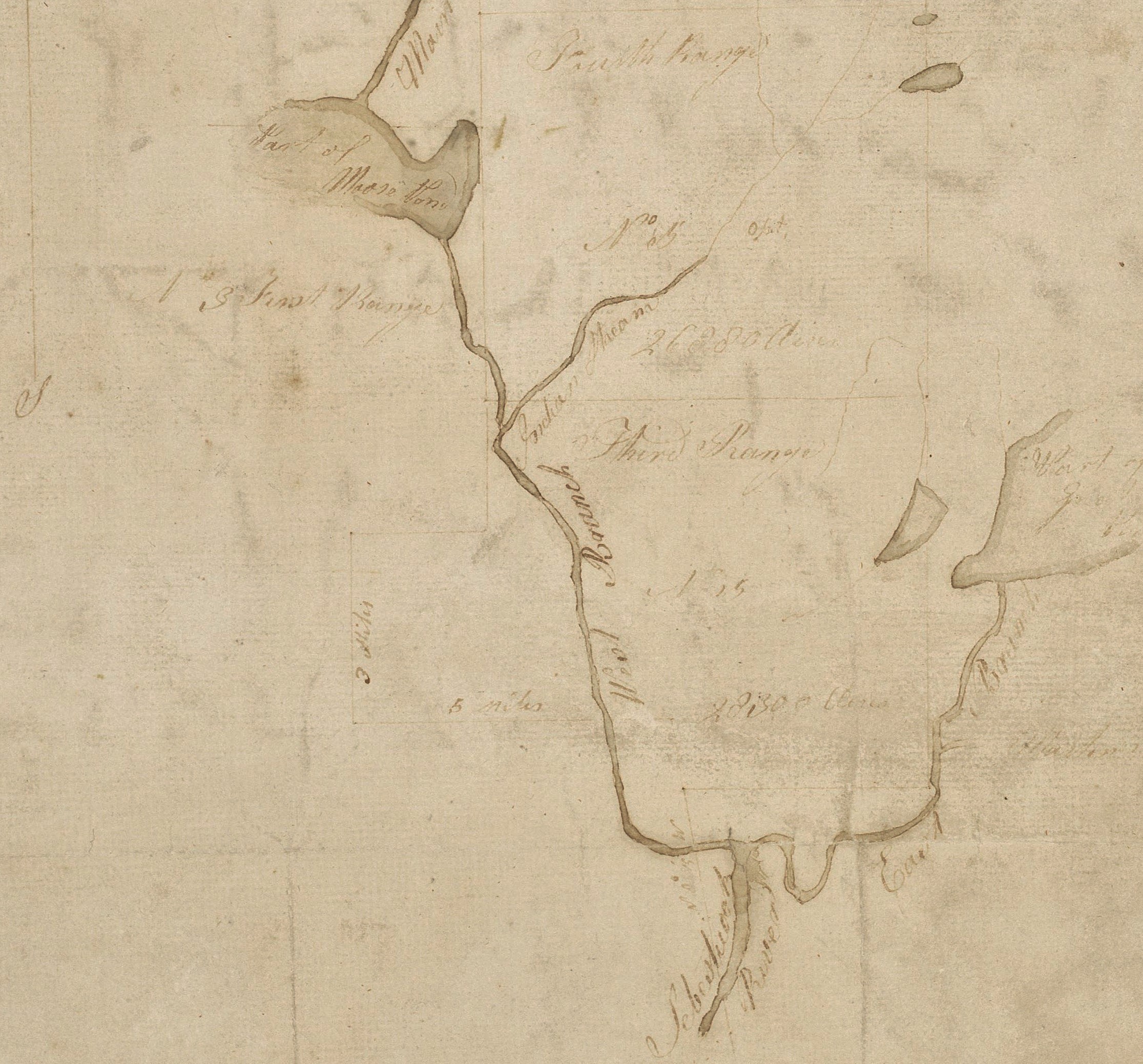
Close-up of Original Ephraim Ballard Map – 1779
(Courtesy of Maine State Library | Digital Maine Repository Collection)
For a complete and enlargeable version of this original map, click the link below:
Original Ballard Map at Digital Maine Repository
*
Upon ratification of its State Constitution on October 25, 1780, Massachusetts Bay Colony took its new name as the Commonwealth of Massachusetts. The Commonwealth was subsequently split into 3 Territorial Districts by the Congressional Congress including the Province of Maine renamed as the District of Maine.
*
Samuel Weston (1757-1802) of Canaan was another prominent surveyor of townships and township lot layouts in the region for various Land Proprietors. His father Joseph Weston was an early settler of the original part of Canaan in 1772 of which parts later became Skowhegan.
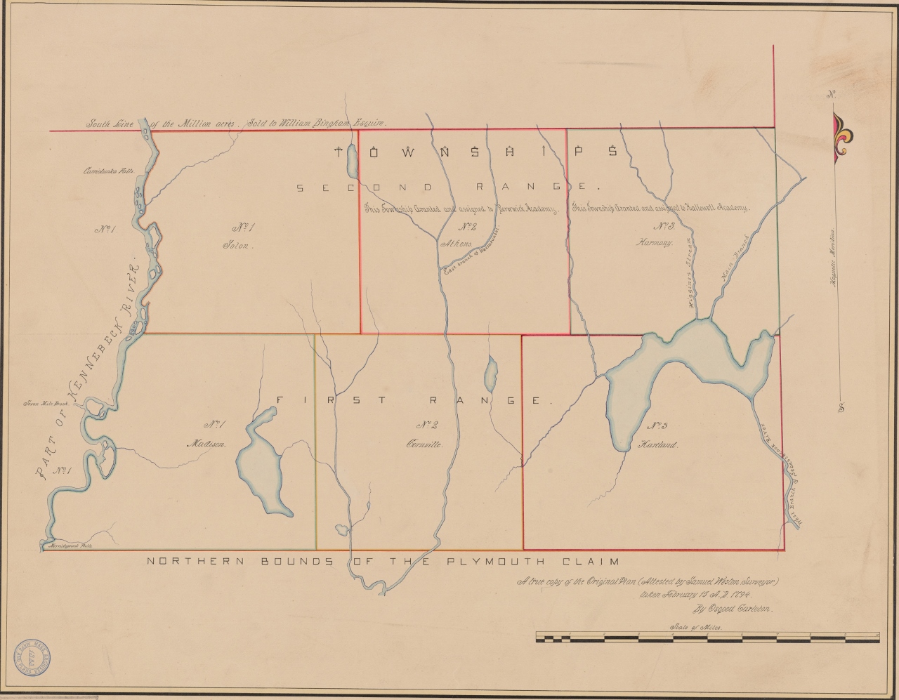
In October of 1790, Samuel Weston surveyed Townships No. 1 (Solon), No. 2 (Athens) & No. 3 (Harmony) in the 2nd Range North of the Plymouth Claim then still part of Lincoln County in the renamed District of Maine. He completed his survey in October of 1791 of the 1st Range including Townships No. 1 (Madison), No. 2 (Cornville) & No. 3 (Hartland). In his completed map seen below, drawn soon after, he included several notations for landmarks and land quality.
It was not uncommon for surveyors to layout townships in relatively squared lots. While convenient for future deed boundary identification purposes, this uniform surveying method often ignored natural boundaries resulting in problematic geographical access to education, town affairs and services for some of those who later settled there.
This map and its original surveyed borders would be referenced in Dr. John Warren’s 1799 Deed of his purchase of the future Town of Hartland reading in part as “Said Township being Number Three in the First Range, North of the Plymouth Claim, on the East side of Kennebec River, as the same was surveyed by Samuel Weston in the year Seventeen Hundred & Ninety-Two”.
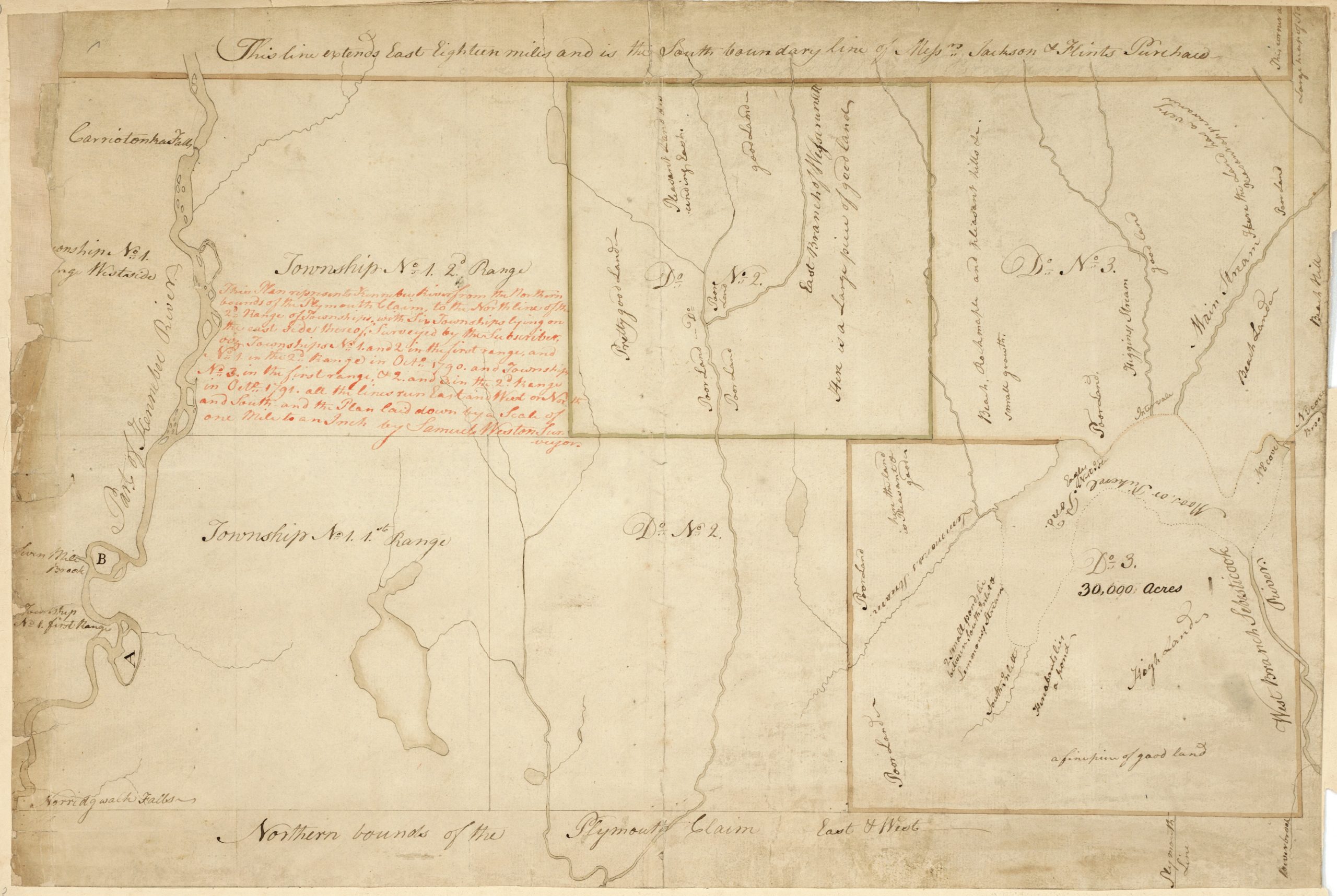
Samuel Weston Survey Map 1790-1791
(Courtesy of Maine State Library | Digital Maine Repository Collection)
For a complete and enlargeable version of this original map, click the link below:
Original Weston Map at Digital Maine Repository
*
As generally defined in the early days of land surveys, a “Gore” was any remnant land between two or more towns or townships. Various gores are noted on early maps throughout the state and had no defined limitations of size or shape. Most were given an unofficial designation as a general reference to their location.
The eastern border line of the Plymouth Claim, as indicated at the bottom right of Weston’s map above, was also the western border of the Waldo Patent and as the western border of the L of Palmyra (aka the Ell) as surveyed by Ephraim Ballard above as part of Township No. 5 in the Third Range of the Waldo Patent.
From the western border of the L, a gore originally unclaimed by any of the nearby townships ran due west in a strip below the surveyed townships of Hartland (No 3), Cornville (No. 2) and Madison (No. 1) in the 1st Range continuing along to the south-west corner of the future town of New Vineyard. This mile and a half deep strip of land accounted for an original section of the northern border of the Plymouth Claim and was part of the larger Plymouth Gore, so called; a 700 square mile unorganized territory continuing south of the L as part of the “new” 1753 Plymouth Claim at the time.
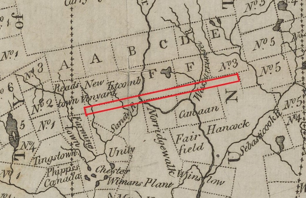
Gore of a Mile and a Half Strip at the Northern Border of the Plymouth Claim – 1795 Carleton Map
*
The “Gore of a Mile and a Half Strip”, so called for most of its north-south depth, is documented by several area towns it bordered until the final deposition of its remaining section of land. Among those noting it by its more common designation as the Mile and a Half Strip is a 1797 Lot Map of Canaan (detailed below), an annexation of a section of the strip by Cornville in 1807 and its claim by Madison and New Vineyard. It was also noted as such as part of the northern border of Warsaw (later renamed as Pittsfield) when it incorporated in 1819 which consisted of a large northern section of the Plymouth Gore.
The section of the Mile and a Half Strip bordering Hartland to the south was NOT included in Dr. John Warren’s 1799 Deed for the purchase of the township which referred to Samuel Weston’s boundaries as surveyed on the map above in part as, “Southerly by the Township (Palmyra) last mentioned, in part, and partly by the Plymouth Claim”, the latter referring to the northern border of said claim.
However, by the time a petition to incorporate as the town of Hartland was raised in 1819, the strip had been claimed as part of Hartland’s southern border as noted in part as, “South by the L of Palmyra and the Mile and a Half Strip, so called”. Those same borders would be reflected in the 1820 incorporation document of Hartland albeit slightly altered as, “Southerly by the L of Palmyra, so called; thence from the west line of said L to the southeast corner of Cornville, including the Mile and a Half Strip”.
Although the strip was technically unclaimed by nearby bordering townships, early documented settlement within its central and western boundaries was common. Some of the early settlers in these parts of the strip had taken advantage of offers by the Kennebec Proprietors for free land to encourage settlement of their northern border area. Some purchased surveyed lots offered by the original or new proprietors while others simply settled on land hoping to eventually gain title by possession.
*
A close-up of the future town of Hartland’s original deeded borders from Weston’s map reveals a few general notes of his assessment of land quality, total acreage and some bodies of water. He noted ‘Lemmons’s Stream’ as what is now known as Black Stream and ‘Moos(e) or Pickerel Pond’ for what is now Great Moose Lake. The ‘2 small ponds’ noted are now Starbird Pond & Bog Pond with the notation ‘hereabouts lies a pond’ now being Stafford Pond. Weston did not include Morrill Pond most likely because only its northern section was part of Hartland’s original surveyed southern border with its remainder laying in the Mile and a Half Strip.
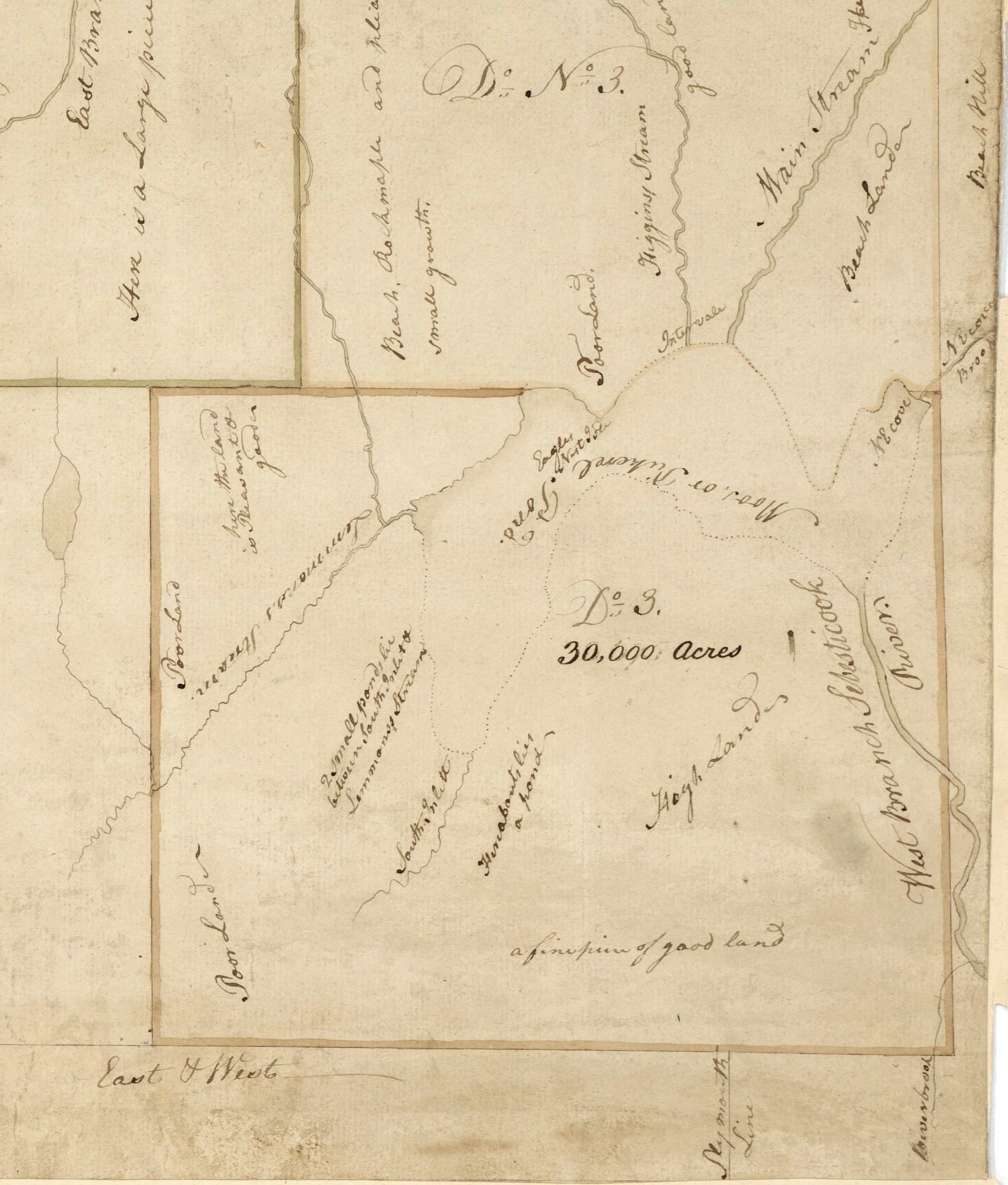
Samuel Weston Township No. 3 Survey Map
*
“A True Copy of the Original Plan (Attested by Samuel Weston, Surveyor) taken February 15, 1794”
An updated version of a map originally made by Osgood Carleton who created a more formal version of Samuel Weston’s original survey map. It is unclear exactly when Carleton created his original map as the only referenced date appears to imply the date is when Weston’s survey was taken. The date of this updated version is also unclear but formal town names had been added to the townships taken when they incorporated including Hartland which was not known as such until its 1819 petition to incorporate after Carleton’s death in 1816.
Solon – Inc. 1809 | Athens – Inc. 1804 | Harmony – Inc. 1803 | Madison – Inc. 1804 | Cornville – Inc. 1798 | Hartland – Inc. 1820
Updated Osgood Carleton Version of the Original Samuel Weston Survey
(Courtesy of Maine State Library | Digital Maine Repository Collection)
For an enlargeable version of this original map, click the link below:
Original Carleton Map at Digital Maine Repository
*
In 1793, Osgood Carleton created this map of the District of Maine with its existing borders at the time. As noted in various publications, Carleton (1741-1816) was a key figure in the early mapping of Maine while it was still part of the Commonwealth of Massachusetts. A land surveyor and teacher of mathematical arts in Boston, he compiled existing manuscript maps and plans into maps of the district for books on U.S. geography and Maine history.
District of Maine by Osgood Carleton – 1793
(Courtesy of Osher Map Library Collection | University of Southern Maine)
For an enlargeable version of this original map, click the link below:
Original 1793 Carleton Map at Osher Library
*
Carleton’s next Map of the District of Maine in 1795 included many new towns and townships including Hartland as Township No. 3.
District of Maine by Osgood Carleton – 1795
(Courtesy of Osher Map Library Collection | University of Southern Maine)
For an enlargeable version of this original map, click the link below:
Original 1795 Carleton Map at Osher Library
*
Another close-up from the 1795 Carleton Map highlighting the original Samuel Weston surveyed and future deeded borders of Hartland by its designation at the time as Township No. 3 in the First Range north of the Plymouth Claim and east of the Kennebec River.
Cropped Image of 1795 Map
*
In order for Proprietors who purchased Townships in the District of Maine to meet several standard settlement obligations required by the Commonwealth of Massachusetts (and of equal priority to both, pay taxes), townships had to be broken into surveyed lots in order to be sold to potential settlers. Typically, a township would first be divided into numbered ranges then subdivided into individual numbered lots which could vary in size from 50 acres to 400 acres depending on the township. Proprietors were given deadline dates to settle a specific number of families within their new townships and each new township was required to reserve specific sized lots for educational, religious and public meeting purposes.
Examples of these lot reservations and settlement obligations were detailed in Dr. Warren’s 1799 Deed for Hartland as such;
“Excepting and reserving however, four lots of three hundred and twenty acres each for the following uses viz.; One lot for the first settled Minister, his heirs or assigns – One lot for the use of the Ministry – One lot for the use of schools – One lot for the future disposition of the General Court. The said lots to average in situation and quality with the other lands in said Township.”
“Provided that the settler his Heirs or assigns shall within one year after notice and request, pay to the grantees named in this Deed, their heirs or assigns, Five dollars, and on this further condition, that the said John Warren, before the twentieth day of June, One Thousand Eight hundred and One, shall settle twenty families within said township, and before the twentieth day of June, One Thousand Eight hundred and Five shall settle twenty families more.”
*
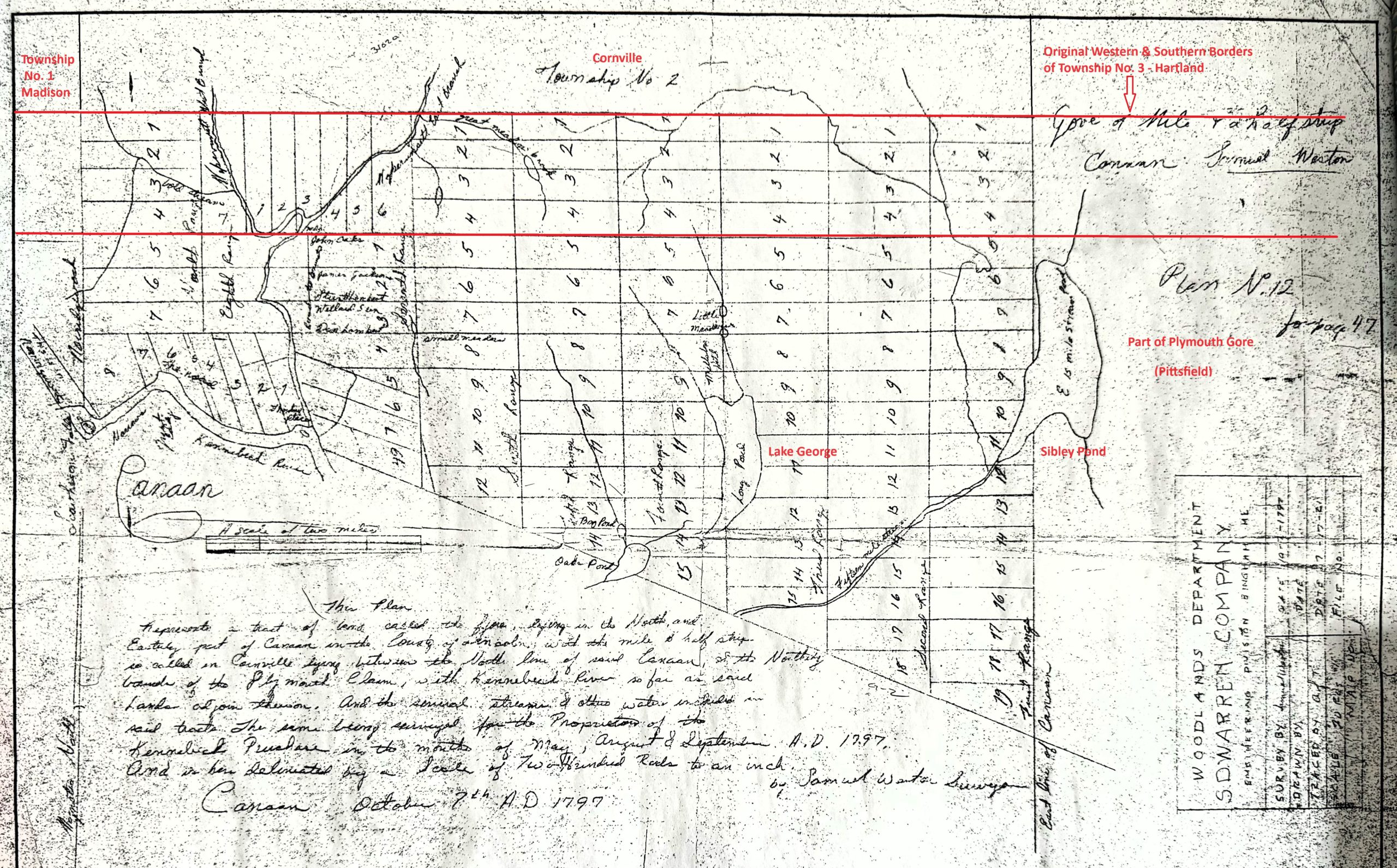
The Mile and a Half Strip was included in a 1797 Lot Map of Canaan before several major boundary line changes were made to it. It was surveyed by Samuel Weston and his assistant Daniel Steward, Jr noting in part, “This plan represents (in part) a tract of land called the Gore lying in the North and Easterly part of Canaan in the County of Lincoln with the Mile and a Half Strip, so called, lying between the North line of Canaan and the Northerly bounds (Township No. 2 Cornville) of the Plymouth Claim”.
As outlined in red in this edited version of the original map, this particular section of the Mile and a Half Strip included all the lots numbered 1 to 4 located in the First Range thru the Ninth Range although it was not part of Canaan’s 1788 incorporated borders. The Strip extended further west and to the east of Canaan as part of the southern border of Hartland’s original surveyed and deeded line.
In 1807, the entire section of the Mile and a Half Strip between Canaan and Cornville was annexed by Cornville. It was set off in the early 1830s as a part of Milburn before changing its name in 1836 becoming part of the new town of Skowhegan which in turn eventually annexed parts of Bloomfield; also formally part of Canaan.
Edited Lot Number & Range Number Map of Canaan – October 7, 1797
(Original Map courtesy of Canaan Historical Society)
*
Several early Hartland land deeds make reference to specific Range & Lot numbers further described as, “a tract of land in Hartland according to a plan made by Samuel Weston, Surveyor, dated October 7, 1797”, suggesting Weston also surveyed and laid out the original Range & Lot Map of future Hartland for the Proprietors of the Kennebec Purchase around the same time as his survey of Canaan above. Our search continues for this historically significant but so far elusive map also generally referenced in future town line border changes.
*
In 1798, Samuel Weston surveyed neighboring Township No. 5 in the 4th Range (St Albans) and Township No. 5 in the 3rd Range (Palmyra including the L), both north of the Waldo Patent, into individual lots for soon to be new proprietor of both, Dr. John Warren of Boston. The map was drawn in a non-typical compass bearing manner with its northern border on the right side and its western border with Hartland at the top noted as Township No. 3 in the 1st Range north of the Plymouth Claim.
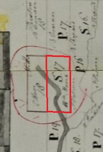
Among those was Lot S-17 in the 1st Range of St Albans bordering Palmyra to the south and Hartland to the west straddling the Sebasticook River roughly centered at the island which William Moor (1776-1848) of Goffstown, New Hampshire had purchased earlier following his exploration of the area around 1796 and eventually settled permanently about 1802.
“This plan represents Townships No. Five in the Third & Fourth Ranges of Townships North of the Waldo Patent & between the rivers of Kennebec & Penobscot. The same being surveyed into lots on the months of September & October A. D. 1798 for Dr. John Warren and is here delineated by the scale of one mile to an inch.” ~ Samuel Weston, Surveyor, Canaan – October 21, 1798
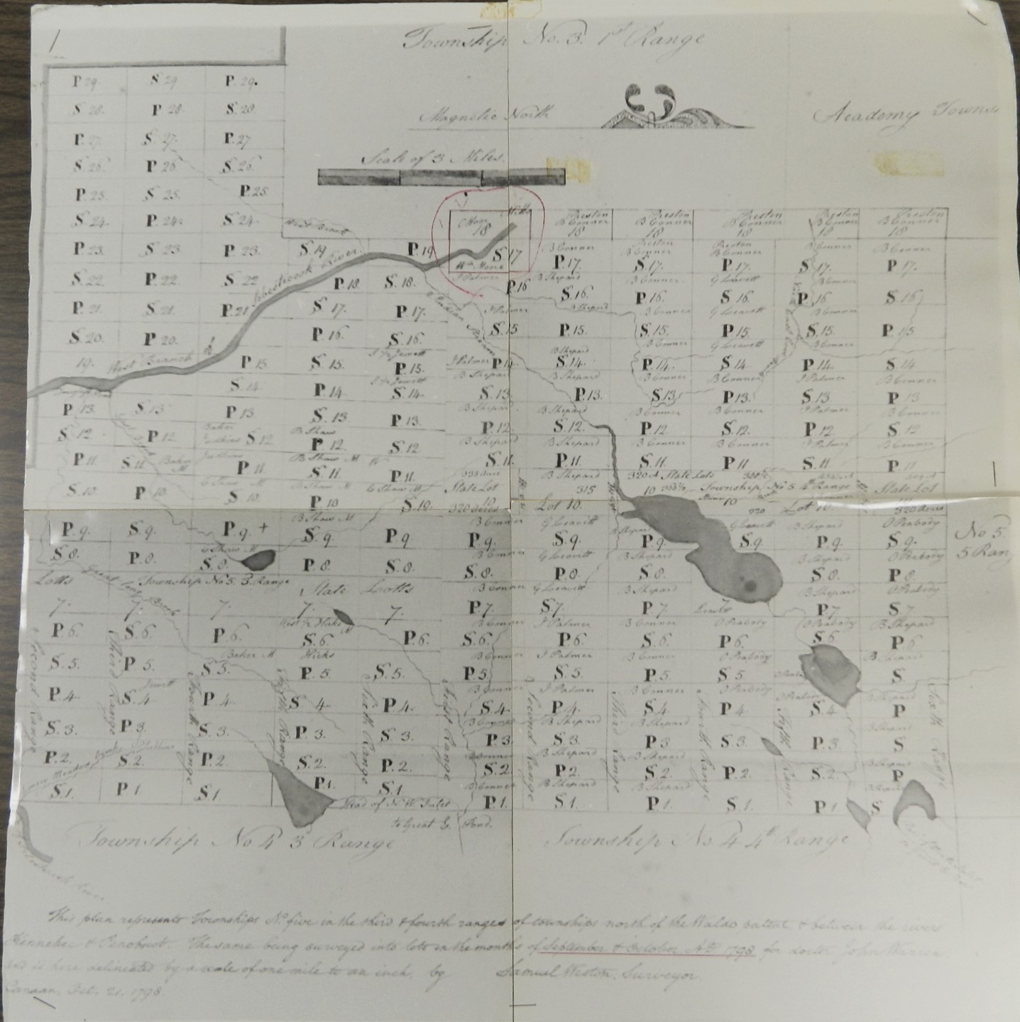
Samuel Weston Range & Lot Map of future Palmyra & St Albans – 1798
*
The western border of William Moor’s lot became part of the original east-west town line between St Albans and Hartland when Hartland incorporated in 1820 dividing a large section of the village area between the two towns near the Sebasticook River. All of Moor’s original lot eventually became part of Hartland as detailed below. Moor is respectfully acknowledged as a pioneer settler of both towns and prominently included in Hartland’s early history for his contributions to the initial settlement and first industry in the future village area as well as having a significant role in early area town affairs.
This edited close-up, rotated to a north-south perspective, highlights the original existing borders as of 1798 of future towns surrounding Moor’s Lot. Since Weston’s primary assignment was to survey St Albans and Palmyra, there were some obvious omissions on his map of Great Moose Lake bordering Hartland and Harmony and only a partial inclusion of its Sebasticook River outlet. Hartland’s original surveyed southern border with the L of Palmyra and the Gore of the Mile and a Half Strip are also highlighted.
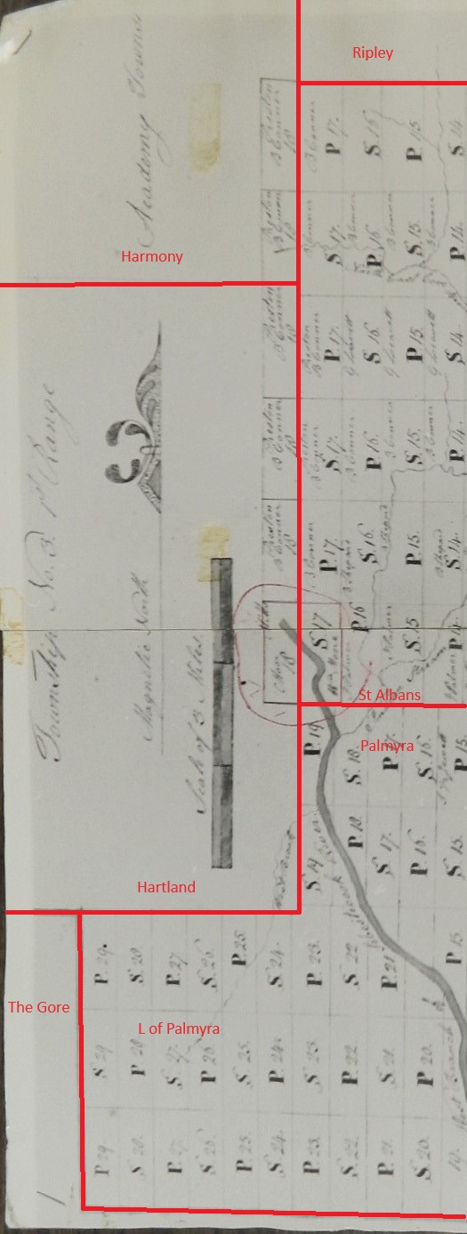
Edited North-South View of 1798 Weston Survey Map
*
A non-scaled visual reference of William Moor’s original lot location in relationship to the village area highlighted on the future 1883 map.
William Moor Lot Location Reference
*
Leading up to Dr. John Warren’s 1799 purchase, Hartland had been contracted from the Kennebec Proprietors on February 26, 1796 by Moses Barnard, Joseph Hilton, Isaac Thom and George Reid of New Hampshire and their associates who also contracted St Albans, Palmyra and Corinna. Moses Barnard had also earlier purchased the future towns of Cornville and Madison. Along with his purchase of Hartland, Dr. Warren bought Township No. 5 in the 4th Range (St Albans) in 1799, Township No. 5 in the 3rd Range (Palmyra) in 1800 and Township No. 4 in the 4th Range (Corinna) in 1804, the latter 3 surveyed as north of the Waldo Patent. These 4 townships, often referred to collectively as “Warren’s Four Towns”, would be interwoven with numerous historical and family connections over the following decades.
*
On June 15, 1799, Dr. John Warren of Boston was formally deeded the future town of Hartland reading in part (with boundary location notes) as, “Know all men by these presents that we, whose names are undersigned and seals are hereunto affixed, appointed as a Committee by the General Court of the Commonwealth of Massachusetts, with full power & authority to sell and convey the unappropriated lands of said Commonwealth lying within the District of Maine, in consideration of Eight Thousand, One Hundred and Forty Nine Dollars and Thirty Cents, to us in hand paid by John Warren of Boston in the County of Suffolk of the Commonwealth of Massachusetts, Physician, for the use of said Commonwealth, the receipt whereof we do hereby acknowledge, have given, granted, sold and conveyed, and by these presents, on behalf of said Commonwealth, do give, grant, sell and convey unto the said John Warren, assignee of Moses Barnard and Joseph Hilton both of Deerfield, and Isaac Thom and George Reid both of Londonderry, and all of the State of New Hampshire, Esquires, and their associates, a Township of land lying in the County of Lincoln, and containing about Thirty Thousand Acres, be it the same or more of 1%, the said Township being Number Three (Hartland) in the First Range, north of the Plymouth Claim, on the east side of the Kennebec River, as the same was surveyed by Samuel Weston in the year Seventeen Hundred & Ninety Two; Bounded easterly by Township Number Five (St Albans) in the Fourth Range north of the Waldo Patent, in part; and partly by Township Number Five (Palmyra) in the Third Range above said (Waldo) Patent; Southerly by the Township (Palmyra) last mentioned in part, and partly by (northern border of) the Plymouth Claim; Westerly by Township Number Two (Cornville) in the First Range north of the Plymouth Claim; and Northerly by Township Number Two (Athens) in the Second Range north of the Plymouth Claim, in part, and partly by Township Number Three (Harmony) in the (Second) Range last mentioned, and by Moos(e) or Pickerel Pond.”
*
The reference to Lincoln County in the deed infers it was penned just before major county boundary changes were made and was not updated at the time of its final signed conveyance to Dr. Warren as then part of Kennebec County. Lincoln County was established June 21, 1760 when York County was first divided. In 1799, extensive parts of Lincoln County were set off into several counties including Kennebec County on February 20, 1799. A northern portion of Kennebec County was then set off incorporating as Somerset County on March 1, 1809 with Norridgewock serving as the original county seat until it was replaced as such by Skowhegan in 1872.
*
Most of the early settlement of Township No. 3, then still part of Kennebec County, was concentrated in its western and northern regions with James Fuller, Sr credited historically as the earliest permanent settler in West Hartland in 1802. Soon after, numerous other families began settling across the West Hartland area as well as across the greater North Hartland region. It is unknown exactly who or when settlement began along the Mile and a Half Strip below Hartland’s surveyed and deeded borders but several names appear in the 1810 Census for Township No. 3 of those known to still be living there in the 1820 Census for Hartland. As previously noted, William Moor also settled in 1802 on the eastern side of the Sebasticook River, then part of St Albans, with further settlement along both sides of the river in the future village area soon after.
*
On October 11, 1819, the inhabitants of Township No. 3, also known among other names as Warrens No. 3 Township and now part of Somerset County, organized as a Plantation just before petitioning the Massachusetts Senate and House of Representatives to Incorporate as the Town of Hartland in 1820. Its incorporation was enacted upon final passage by the House on February 4th, the Senate on February 5th then signed into law by Governor John Brooks on February 7, 1820.
“We, your petitioners, inhabitants of Township No. Three, so called, bounded West by Cornville, North by Athens and Harmony, East by St. Albans and Palmyra and South by the Ell of Palmyra and the Mile and a Half Strip, so called, humbly represent that there is upwards of fifty families in said Township, and that we labor under many and great inconveniences whereby we cannot in our present situation by any legal means raise money for the support of schools or the making or repairing of roads. We therefore pray your honors to incorporate said Township in a town by the name of Hartland, and as in duty bound we pray.”
*
The 1819 Petition is the first known documented reference to the Mile and a Half Strip as such which ran below Hartland’s original 1791 surveyed and 1799 deeded southern border. No records to formally annex the strip by legislative act have been found but settlement along the strip had occurred well before the petition was written thus all those settlers became citizens of the new town of Hartland in 1820.
*
A little over a month later on March 15, 1820, the District of Maine separated from the Commonwealth of Massachusetts as the 23rd State of the Union and would first be mapped as such, along with the new town of Hartland, on an 1820 Map made soon after by Moses Greenleaf.
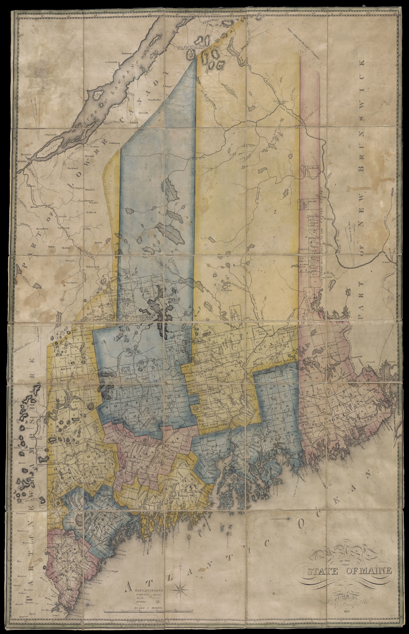
Map of Maine by Moses Greenleaf – 1820
(Courtesy of Osher Map Library Collection | University of Southern Maine)
For an enlargeable version of this original map, click the link below:
Original 1820 Map of Maine at Osher Library
*
It was not uncommon for cartographers to use combinations of survey maps or deeds as part of their resources to indicate map border lines. However, sometimes these sources were outdated and unintentional errors were made on the final rendering. We may presume this the case when Hartland’s southern border was erroneously drawn on Greenleaf’s map with its originally surveyed and deeded border without the documented addition of the Mile and a Half Strip.
This edited version of the original 1820 Greenleaf Map includes the approximate location of the additional Mile and a Half Strip southern border.
(Edited) Hartland Southern Border with Mile and a Half Strip from Greenleaf’s 1820 Map of Maine
*
Like many towns whose borders had originally been surveyed into fairly uniformed lots with little regard to local geography, Hartland’s newly established town lines began to be altered soon after its incorporation. All of its borders would change in some form before its current borders were established most commonly due to geographical obstructions limiting access to involvement in town affairs for some of its citizens.
*
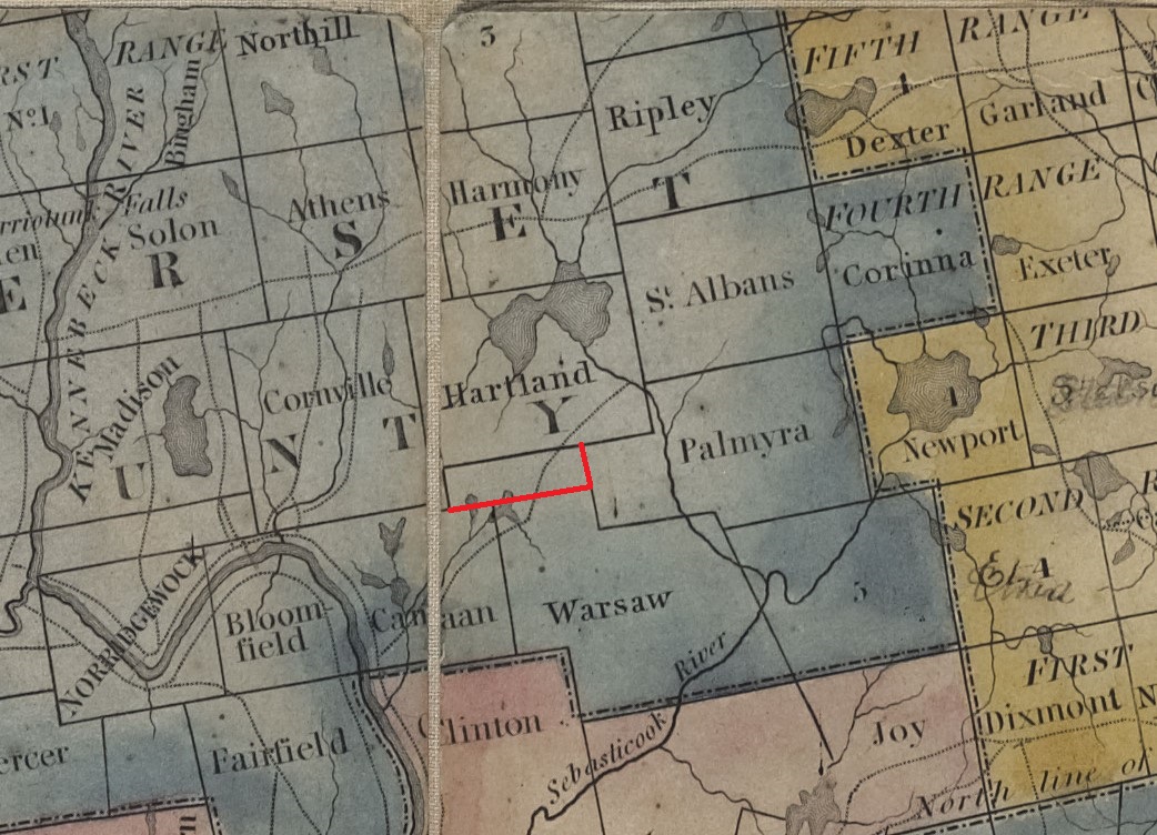
~ 1821 North-Western Hartland Town Line Change ~
The first major boundary change to Hartland was proposed soon after it had incorporated following a citizen’s petition to alter its original northwestern line with Athens, Cornville & Harmony as acknowledged on June 10, 1820 for consideration at its next session by the Maine State Legislature. The petition was written and signed by some of the inhabitants living north-west of Lemons Stream (later renamed as Black Stream) who proclaimed the seasonably flooding stream and surrounding swamp area was often impossible to cross and made it impractical to build a road over thus they were “deprived of the rights and privileges enjoyed by others in their town meetings” held on the south side of the area. The petition was passed by Maine State Legislative Act on February 8, 1821 establishing Lemons Stream as the new northwestern town line between Hartland and Athens. As a result, Hartland’s original western border with Cornville was shortened and a western part of its northern border with Harmony was eliminated however its small border northeasterly of Great Moose Lake with Harmony remained as such.
“Be it enacted by the Senate and House of Representatives in Legislature assembled; That, that part of the Town of Hartland, included in the following limits, to wit; beginning at the northwest corner of said Hartland, and running south on the town line, to a stream (Black Stream) running from a pond (Barker Pond via Tuttle Brook) in the northeast corner of Cornville, into Moose Pond; thence easterly by said stream to Moose Pond; thence by said pond, to the south line of Harmony; thence westerly on said south line, to the bounds first named, together with the inhabitants thereon, be, and hereby is, set off from the said Town of Hartland, and annexed to the Town of Athens.”
New Northwestern Town Line established in 1821 at Black Stream between Hartland & Athens as seen below from the 1883 Map.
Hartland-Athens Town Line – 1883
*
~ 1821 North-Eastern Hartland Town Line Change ~
Immediately following, a second major boundary change was made at part of Hartland’s original surveyed and incorporated eastern border with St Albans and its small northern border with Harmony as passed by Maine State Legislative Act on March 15, 1821.
“Be it enacted by the Senate and House of Representatives in Legislature assembled; That all that part of the Town of Hartland, lying east of Moose Pond, and the center of the stream issuing therefrom, and a line running a due north course from the head of said stream, through said pond to the south line of the Town of Harmony, together with the inhabitants thereon, be, and hereby is set off from the said Town of Hartland and annexed to the Town of St. Albans.”
As illustrated below, one side of the annexed area began at the northwestern corner of William Moor’s Lot Number 17 in St Albans following a course due north on the original eastern border with St Albans to Harmony. The other side included a small section of land west of the northwestern side of Moor’s lot continuing northerly along the Sebasticook River and Great Moose Lake to its former border with Harmony which would thus border St Albans as a result of the annexation.
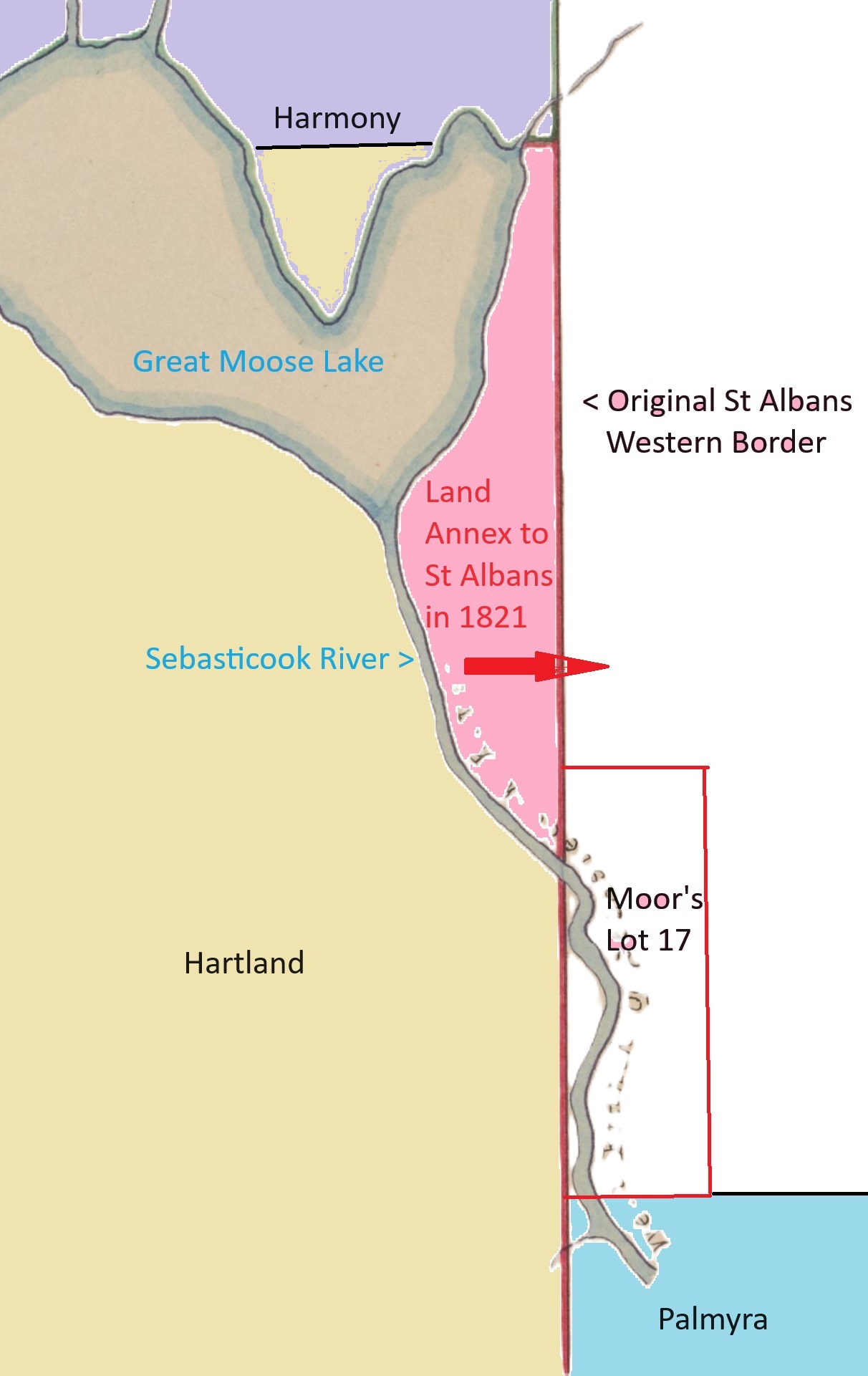
1821 Land Annexation to St Albans
*
All of William Moor’s original Lot 17 remained part of St Albans including the southwest section which crossed the Sebasticook River. This section sustained that part of St Albans’ original southern border with Palmyra and its western border with Hartland as illustrated below using a template of the 1883 map with future streets included for reference as to where the village area remained divided in 1821. By this time, Moor had already divided up most of his original lot into multiple properties sold to new settlers in the village area before he moved to Corinna in the mid-1820s.
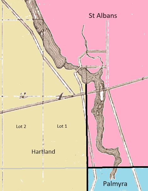
1821 Village Area Borders
*
~ Early Unsuccessful Attempts to change Village Area Borders ~
A few issues with the southwest portion of the village area which had remained part of St Albans began to arise soon after 1821. As early as 1826, Hartland Town Meetings began to include articles brought to voters regarding the question of an extension of its western town line to the Sebasticook River to include the contentious section. No direct actions were taken by voters on any of these articles and instead a committee was formed to further investigate the possible border change and its ramifications but no agreed upon resolution would be brought forth at the time.
Some citizens of Hartland in the village area felt there was an entirely different alternative to an extension of its town line to the Sebasticook River. In 1828, a formal petition was raised in an attempt to instead annex all of Lot No. 1 in Hartland (as seen above) to St Albans. The petition, albeit with no known record of approval by Hartland voters, was raised and sent to the Maine Legislature by a handful of citizens whose properties on Lot No. 1 either bordered and/or straddled the St Albans western town line in the village area. The unsuccessful petitioners, including James Moor (son of William Moor), Horatio Alden and brothers Thomas & Hiram Dorman, noted in part the existing border made it difficult for new settlement in the growing area as it was divided and that they were “subject to the inconveniency” of paying taxes to both towns and purchasing water privileges from St Albans for their mills.
“They therefore pray that all that part of Hartland, which is situated north and east of the following line, may be set off from the town of Hartland, and annexed to the town of St. Albans to wit; Beginning at the southwest corner of the town of St. Albans, thence west to the west line of Lot Numbered One, Range Three in the town of Hartland; thence north on the west line of Lot Number One to the town line of St. Albans, and as in duty bound will ever pray.”
*
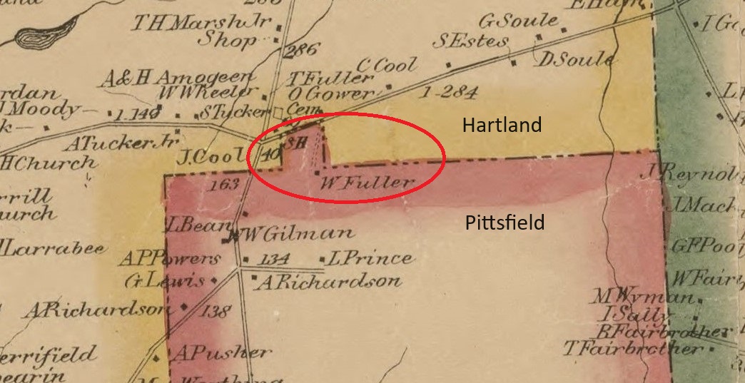
~ 1824 & 1828 Border Changes at The L ~
On February 12, 1824, a southern section of the L of Palmyra was annexed to Warsaw which changed its name to Pittsfield 2 days later on February 14th. On February 23, 1828, Pittsfield annexed the remainder of the L from Palmyra. Neither of these annexations changed Hartland’s territory but did alter the border locations of its eastern and southeastern neighbors. For reasons unknown, these specific legislated border changes did not appear on several future maps until 1860.
*
1843 Map of Somerset County with new and existing Towns & Townships.
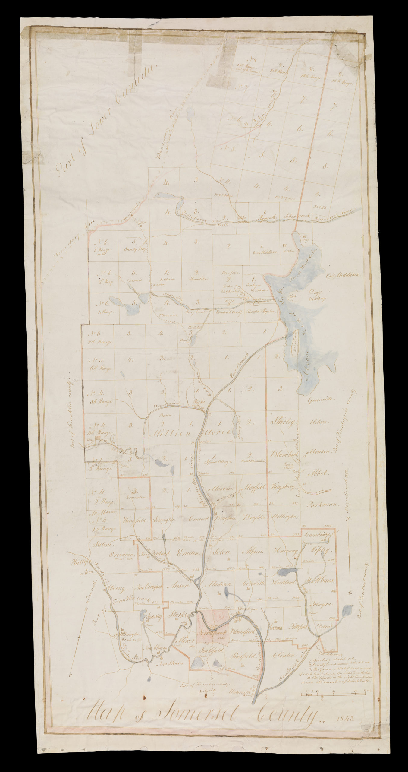
Somerset County – 1843
(Courtesy of Osher Map Library Collection | University of Southern Maine)
For an enlargeable version of this original map, click the link below:
Original 1843 Map of Somerset County at Osher Library
*
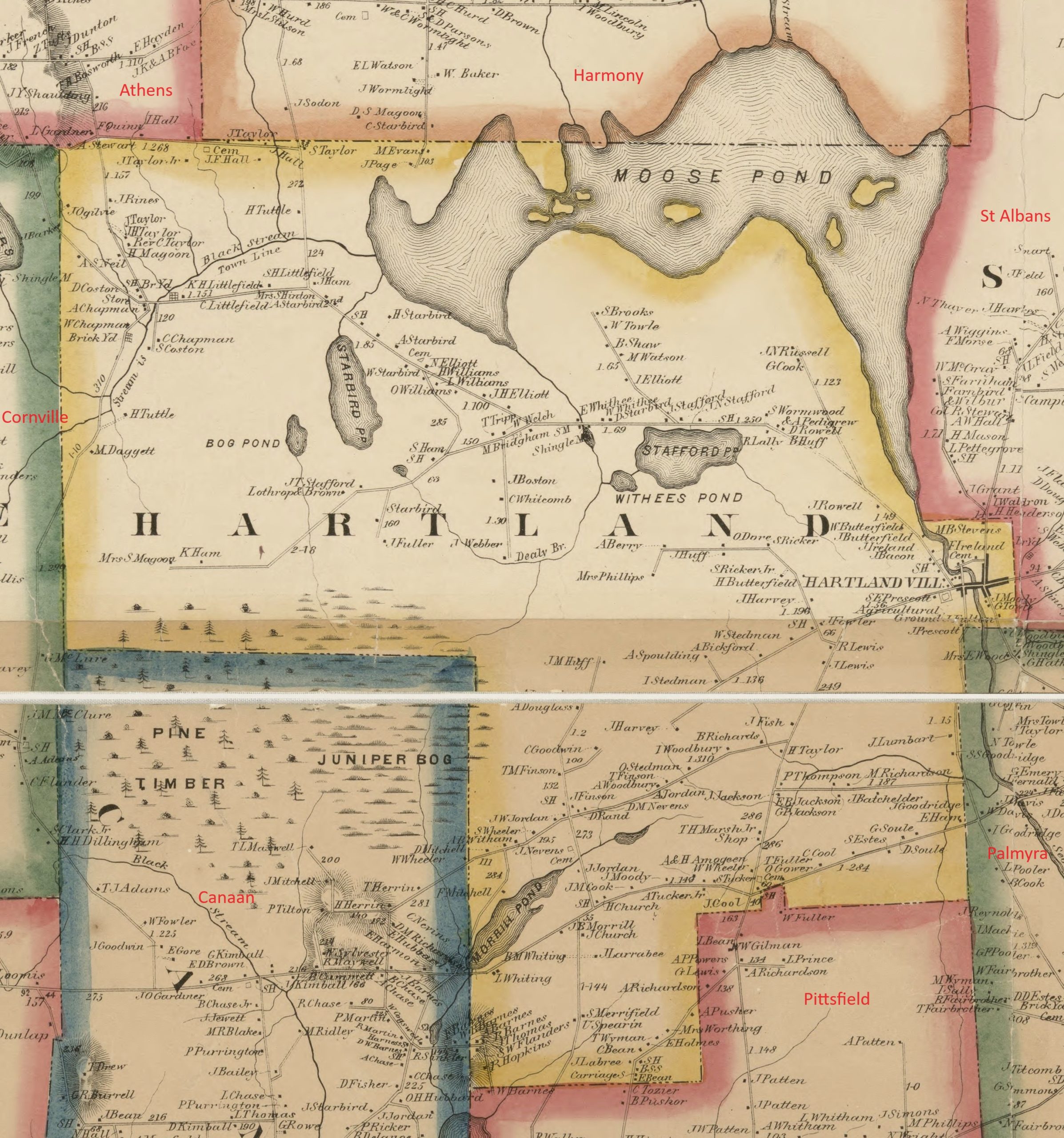
A close-up of the 1843 Somerset County Map reveals the inclusion of the former section of the Mile and a Half Strip claimed as part of Hartland when it incorporated. The 1821 Sebasticook River border change with St Albans is included but without border detail at the village area. Not included is the 1821 altered town line with Athens at Black Stream in North Hartland nor any of the smaller area ponds including Morrill Pond and Sibley Pond. Big Indian Pond and Indian Stream’s confluence with the Sebasticook River are misplaced on the map although the symbol for the location of the newly constructed St Albans Baptist Church (soon to be Hartland Baptist Church) is reasonably close. Only a portion of the entire area annexed from Palmyra by Pittsfield in 1824 & 1828 at the L is included.
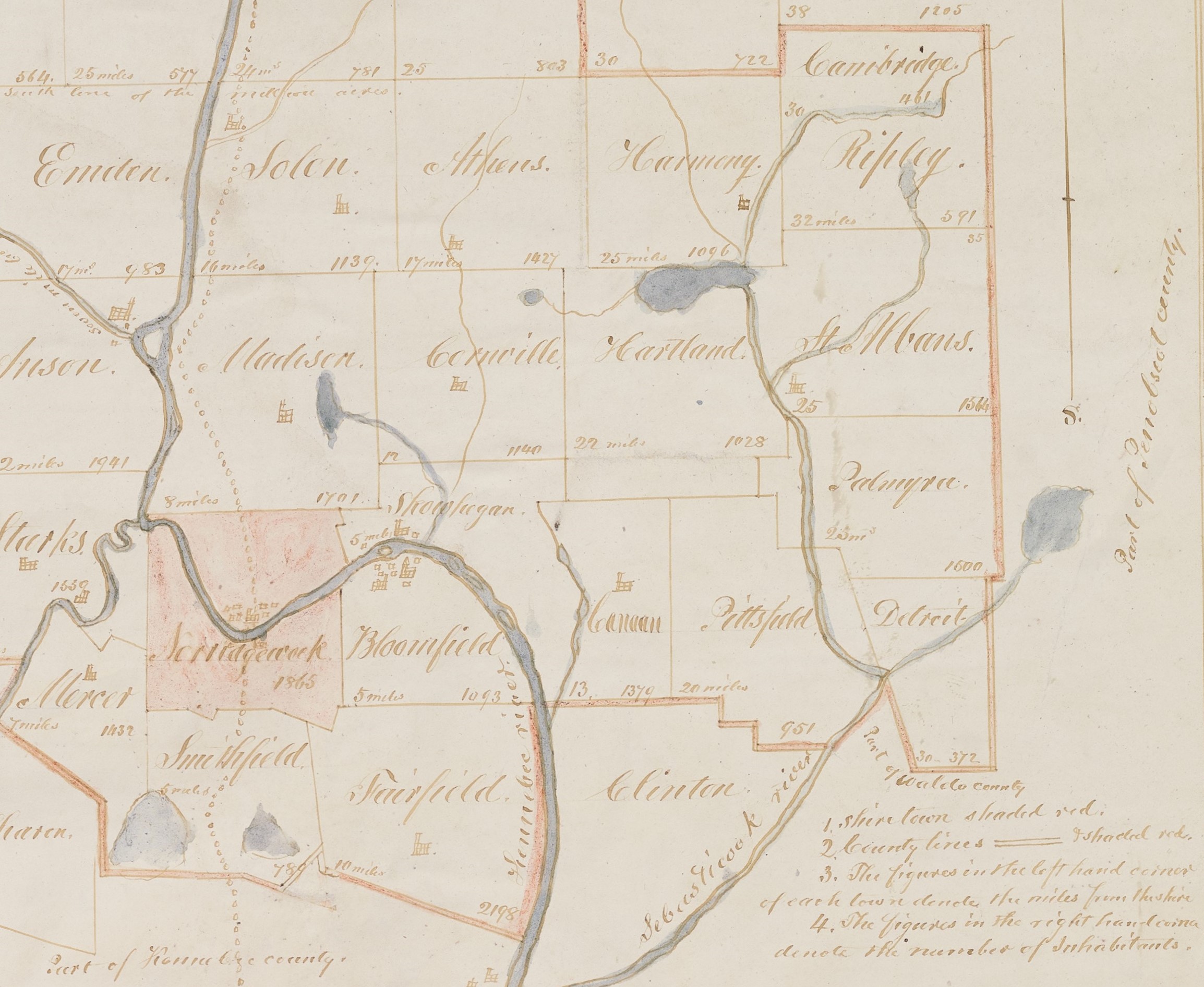
Hartland from Somerset County Map – 1843
*
~ 1846 Hartland Village Town Line Change ~
Several discussions leading up to this change had occurred in both towns as major growth in population, industry and commerce on both sides of the village area over the years had further escalated old issues and since created new concerns with the divided village area border. Some of these concerns had also grown even more so as the shifting population and location of town government of St Albans began centralizing at the foot of Big Indian Pond in the late 1820s putting those St Albans citizens residing near the Sebasticook River further away from easily accessible participation in their town affairs.
Finally in 1846, a formal petition to change the existing borders was raised by those inhabitants of St Albans who resided on the eastern side of the village which was presented and accepted by both towns then sent to the Maine State Legislature for consideration. The petition noted the existing borders cut up the village, made it difficult to properly tax and made schooling a problem. It concluded by stating the proposed line changes, “Would enlarge the power of doing good, augment the facilities of business, swell the population, give spirit & vivacity, cause a union of exertion, contribute to diminish jealously, increase happiness & prosperity and produce efforts salutary and desirable.”
On August 7, 1846, the Legislature formally approved an Act to again alter some of the Hartland and St Albans town line on the eastern and a part of the western side of the village reading in part as, “From and after the passage of this act, all that part of the Town of St Albans, in the County of Somerset, which lies west of Lot Numbered Sixteen, in the First Range of lots in said Town of St Albans, be, and is hereby set off from said Town of St Albans and annexed to the Town of Hartland in said County.”
As seen on this illustrated future map of 1883 as reference, the majority of this annexed land was William Moor’s entire original Lot Seventeen which had since been divided into multiple properties. Also included was a small section of land to the west of Moor’s lot bordering the Sebasticook River which had been previously annexed from Hartland to St Albans in 1821.
These changes established the current borders of the village area with St Albans and an expanded border with Palmyra as such; An east-west line at the end of Commercial Street to the north, a north-south line at the end of Academy Street to the east and an east-west line to the south at St Albans’ former border with Palmyra at the end of Elm Street. Those former St Albans residents and businesses in that area including the Academy became part of the Town of Hartland.

Hartland Village following 1846 Land Annexation from St Albans
*
~ 1849 South-Western Hartland Town Line Change ~
In 1849, two separate formal petitions were raised proposing an annexation of a section of West Hartland to Canaan. The first petition was raised by a small group of citizens who actually resided in the area they presented for annexation citing numerous disadvantages their current inclusion as part of Hartland brought upon them. They noted the long distance to attend town meetings, now held more frequently in the Village, limited their participation in town affairs as well as the difficulty they faced to travel via the road which they had to “cross the alps” (Huff Hill) to reach the Village. Their plea concluded since there was also an existing flow of goods & services already established with Canaan Village and, with its closer proximity on a “good road” as such, they should be part of Canaan.
Although this first petition would be presented to the State Legislature for consideration, a second petition was also brought forth which proposed, for reasons unknown, an even larger section of land to be annexed to Canaan. It was the latter petition’s proposed new boundaries, roughly double in size the area of the first petition, which was accepted by Hartland & Canaan voters and ultimately enacted by the Legislature on July 17, 1849, reading in part as;
“The following described tract of land and the inhabitants thereon and their estates, be, and the same are hereby set off from the Town of Hartland and annexed to the Town of Canaan, to wit; beginning at the southwest corner of said Hartland; thence northerly, on the west line of said Hartland to the range line between Ranges Two and Three in said town; thence east on said range line to the east line of Lot numbered Thirteen in the Second Range; thence south on the east line of Lots numbered Thirteen in the Second and First Ranges of lots in said town to the southeast corner of Lot numbered Thirteen in the First Range of lots in said Hartland; thence in a southerly direction to the center of the bridge across the outlet of the stream leading from Morrill Pond, so called; thence southerly down said stream until it intersects a line running due north from the northeast corner of said Canaan; thence south to the northeast corner of the said Town of Canaan; thence west on the south line of said Hartland to the place of beginning.” With this, many surviving pioneer settlers of what was Hartland and their descendants became citizens of Canaan.
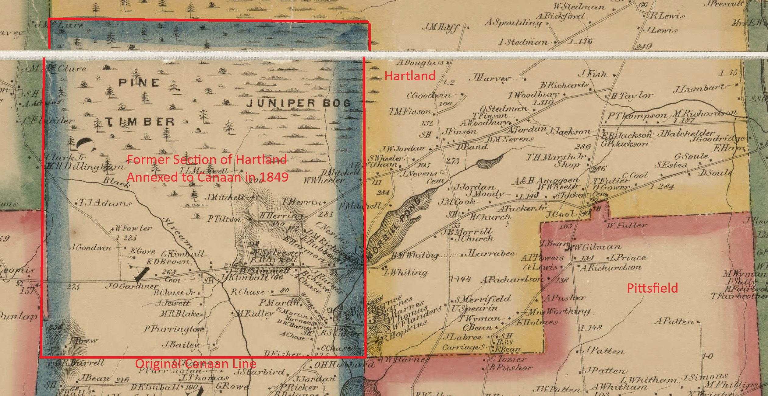
Section of Hartland Annexed to Canaan from 1860 Somerset County Map
*
Following the 1849 land annexation to Canaan, a solid granite marker was placed at the corner marking the newly established boundaries of Hartland, Canaan & Pittsfield. The current land owner graciously took us to the site in 2025 to photograph this historic landmark.


Granite Tri-Town Line Marker
*
~ 1849 Hartland Village Line Change Petition ~
Albeit unsuccessful, a noteworthy petition was raised in 1849 by a dozen inhabitants of the “new” Hartland Village led by Dr. Calvin Blake who had settled in 1825 in then St Albans on future Academy Street as one of the first area physicians. The petitioners, apparently displeased with the state of affairs in their new town, proposed the entire section of the village annexed in 1846 be given back to St Albans, however it was not accepted by Hartland voters and never enacted by the Legislature.
*
~ 1852 Warren Fuller Lot Town Line Change ~
In 1852, John Warren Fuller (1814-1887), known as Warren Fuller, petitioned the Maine Legislature to annex his 15 acre property in West Hartland to Pittsfield. Fuller, eldest child of pioneer settler James Fuller Sr, had been an active member in town affairs having served as Town Constable and at the time of his petition was Representative to the Maine Legislature. Local legend holds there was some kind of dispute between Fuller and Hartland town officials concerning the handling of certain affairs. Regardless of what actually happened to prompt his rather defiant action, Fuller’s petition was successfully enacted on March 11, 1852 and his entire homestead became part of Pittsfield. Although a formal legislative attempt was made by Pittsfield to gift Fuller’s lot back to Hartland in 1969, it would not become part of Hartland again until March 28, 1997 when the 118th Legislature enacted LD71; “An Act to Return a Certain Parcel of Land to Hartland from Pittsfield”.
Warren Fuller Annexed Lot from 1860 Somerset County Map
*
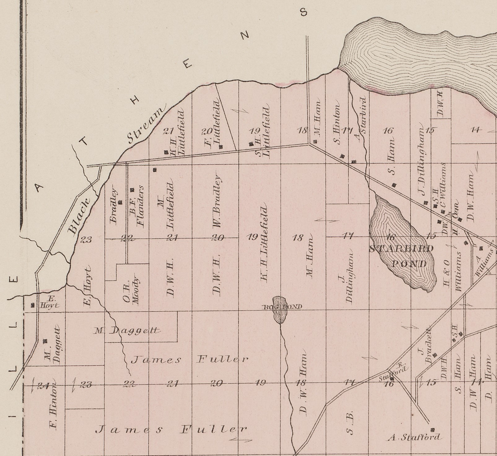
The 1860 Somerset County Map included a fairly accurate portrayal of Hartland indicating most of its updated borders at the time and while the color coding placement for its northwesterly boundary is incorrect, it does properly note “Stream is Town Line” as altered in 1821. The map included the remaining northeastern border with St Albans as annexed in 1821 and subsequent alteration to the village area in 1846. Its southwesterly borders with Canaan and Cornville re-established in 1849 are included as well as the proper borders of the former Palmyra L within Pittsfield as set in 1828. Numerous dwelling locations are also noted with names of some of its residents, the existing schoolhouses (SH) along with some of the various businesses and cemeteries located throughout the town at the time.
Hartland – 1860 Somerset County Map
(Courtesy of Library of Congress)
For a complete and enlargeable version of this original map, click the link below:
1860 Map at Library of Congress
*
An original 1860 Somerset County Map was graciously donated to the Hartland Historical Society by Gary Hanson on behalf of his paternal grandparents Perley & “Bertie” (Wilkins) Hanson who moved to Hartland and had possession of the map for many decades.
*
The 1860 Map of Somerset County also included a detailed insert showing most of the village area now all part of Hartland following the 1846 annexation from St Albans. Many of these family surnames, streets, businesses and other historically significant places noted may be found throughout our website on their respective dedicated pages listed in the pull down menu at the top of the page.
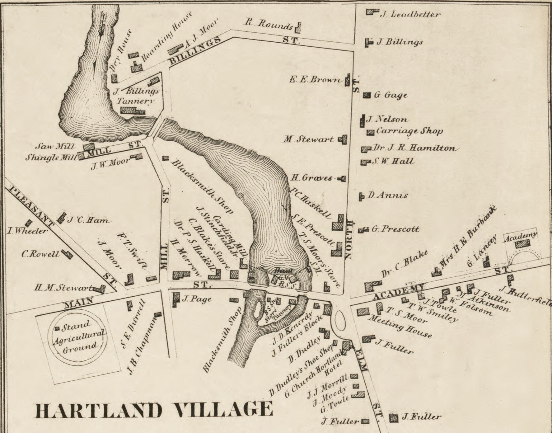
Hartland Village – Insert from 1860 Somerset County Map
*
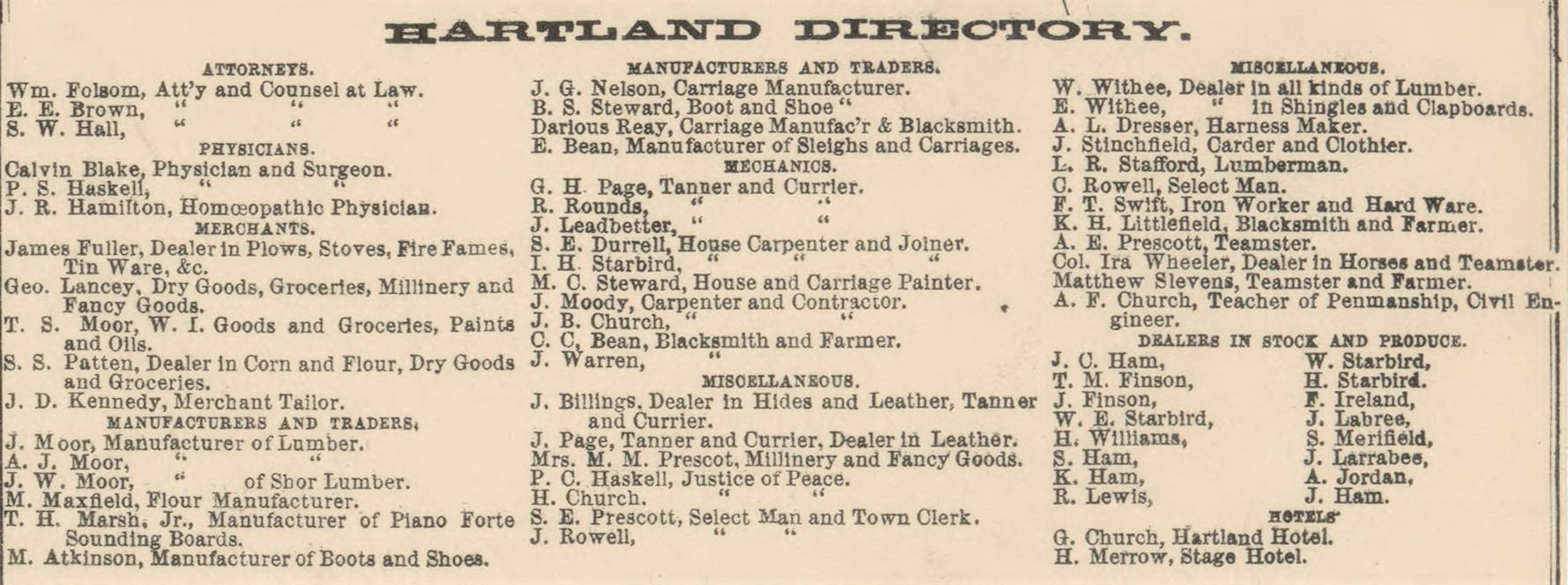
Directory of Hartland – Insert from 1860 Somerset County Map
*
In 1883, a detailed layout of Hartland was included in the Somerset County Atlas with most of its proper boundary lines. Indicated on the map are land lots with property owner names and dwelling locations, existing schoolhouses (SH), and some of the various businesses & cemeteries located throughout the town at the time.
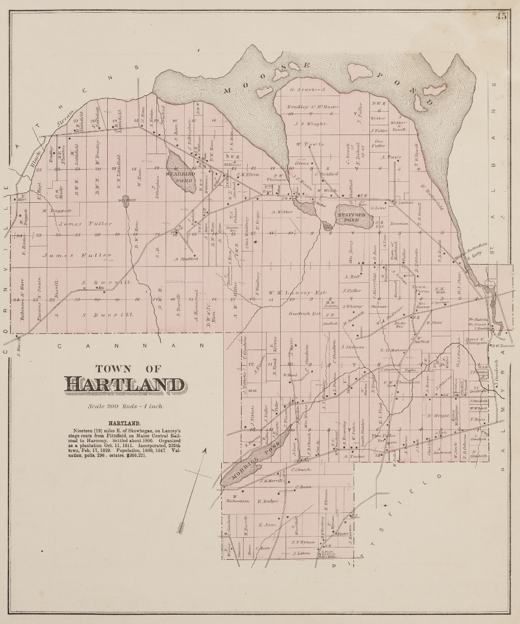
Hartland – 1883 Atlas of Somerset County by George N. Colby & Company
(Courtesy of Maine State Library | Digital Maine Repository Collection)
For an enlargeable version of this original map, click on the link below:
1883 Map at Digital Maine Repository
*
The 1883 Atlas of Somerset County includes a detailed map of most of Hartland Village reflecting its substantial industrial, commerce and population growth since 1860 as it had evolved to become the industrial and new political center of town affairs which had originally been concentrated mostly in West Hartland since its incorporation. In 1886, the Sebasticook & Moosehead Railroad would open a new line connecting Hartland to Pittsfield further enhancing growth in the village area.
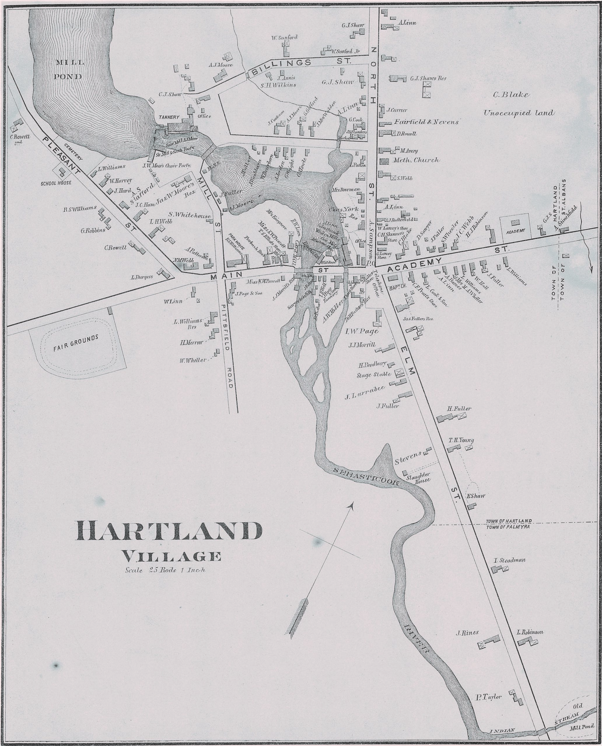
Hartland Village – 1883 Atlas of Somerset County by George N. Colby & Company
An original 1896 “Bird’s Eye View” Map of Hartland Village purchased by Albion K. Libby in 1896 was graciously loaned to us for digital and hard copy reproduction by his grandson Wayne Libby. Our special thanks to E. W. Littlefield & Sons Construction of Hartland for funding the high resolution laser scanning process for our collection.
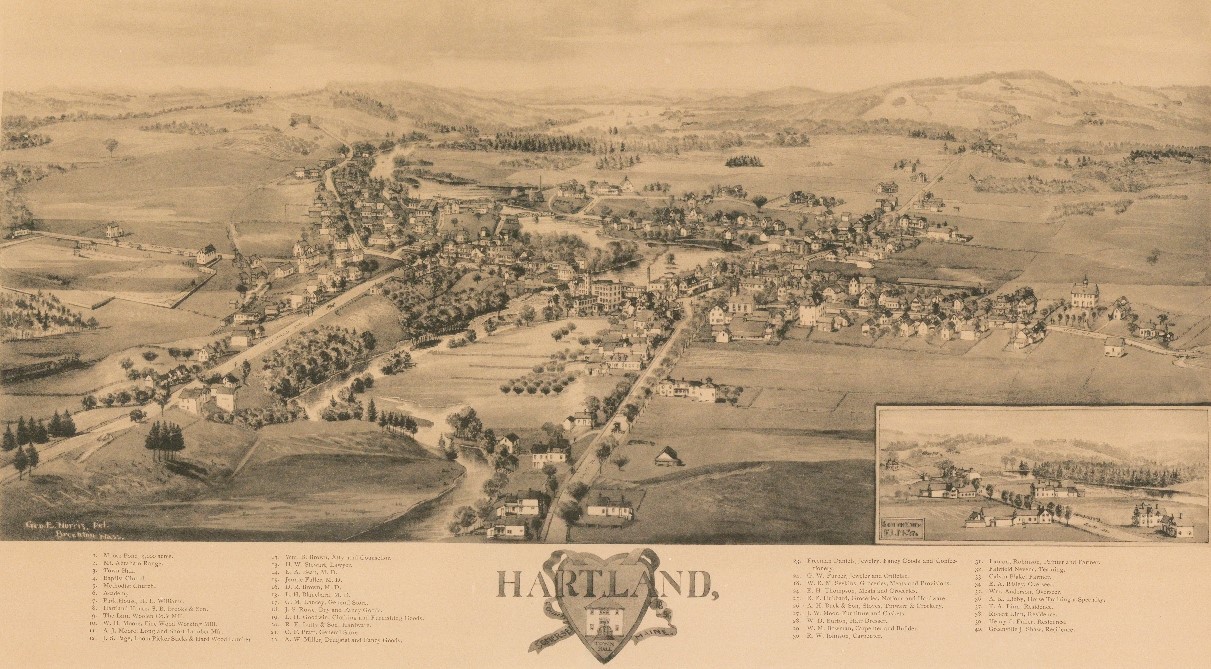
Hartland Village – 1896
(Courtesy of Wayne Libby)
For an enlargeable version of this map, click on the link below:
*
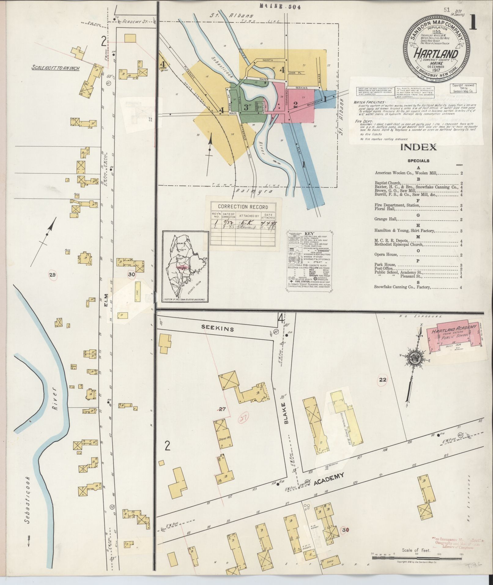
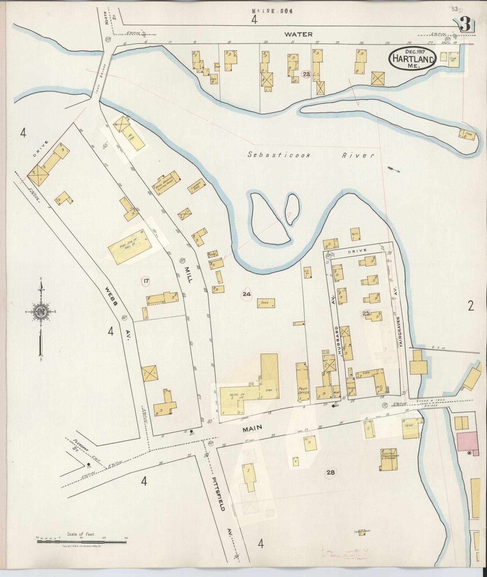
The first of two Sanborn Company Fire Insurance Maps of Hartland Village were completed in December of 1917. The 4 page map provides exquisite details of businesses and homes throughout the Village at the time.
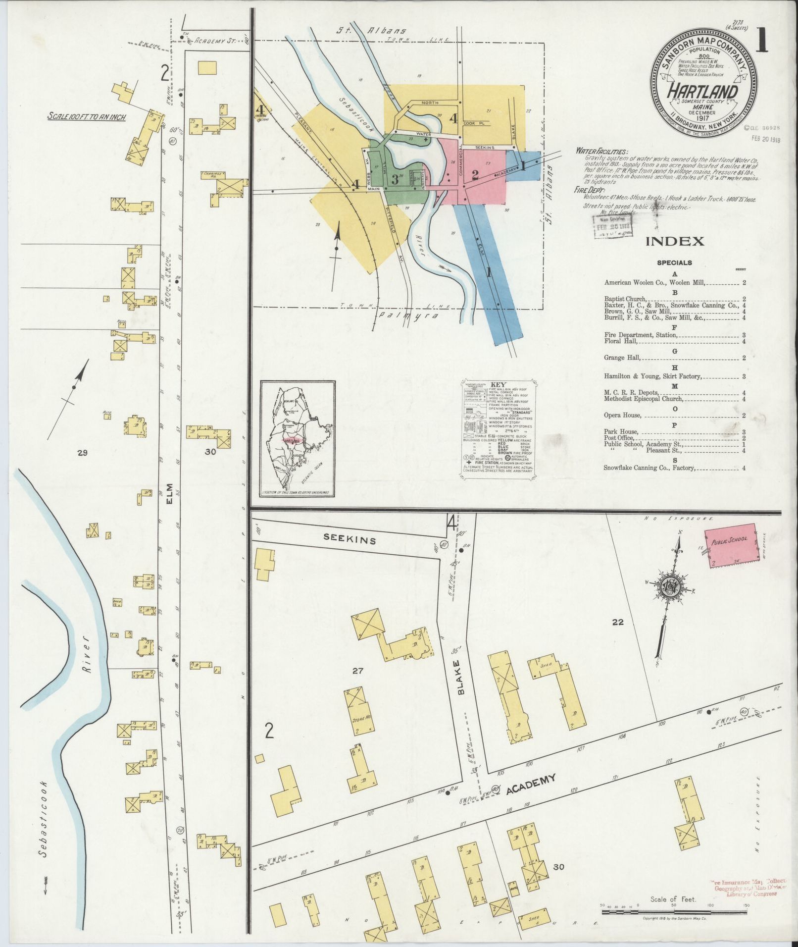
Page 1 – Sanborn Company Fire Insurance Map – 1917
*
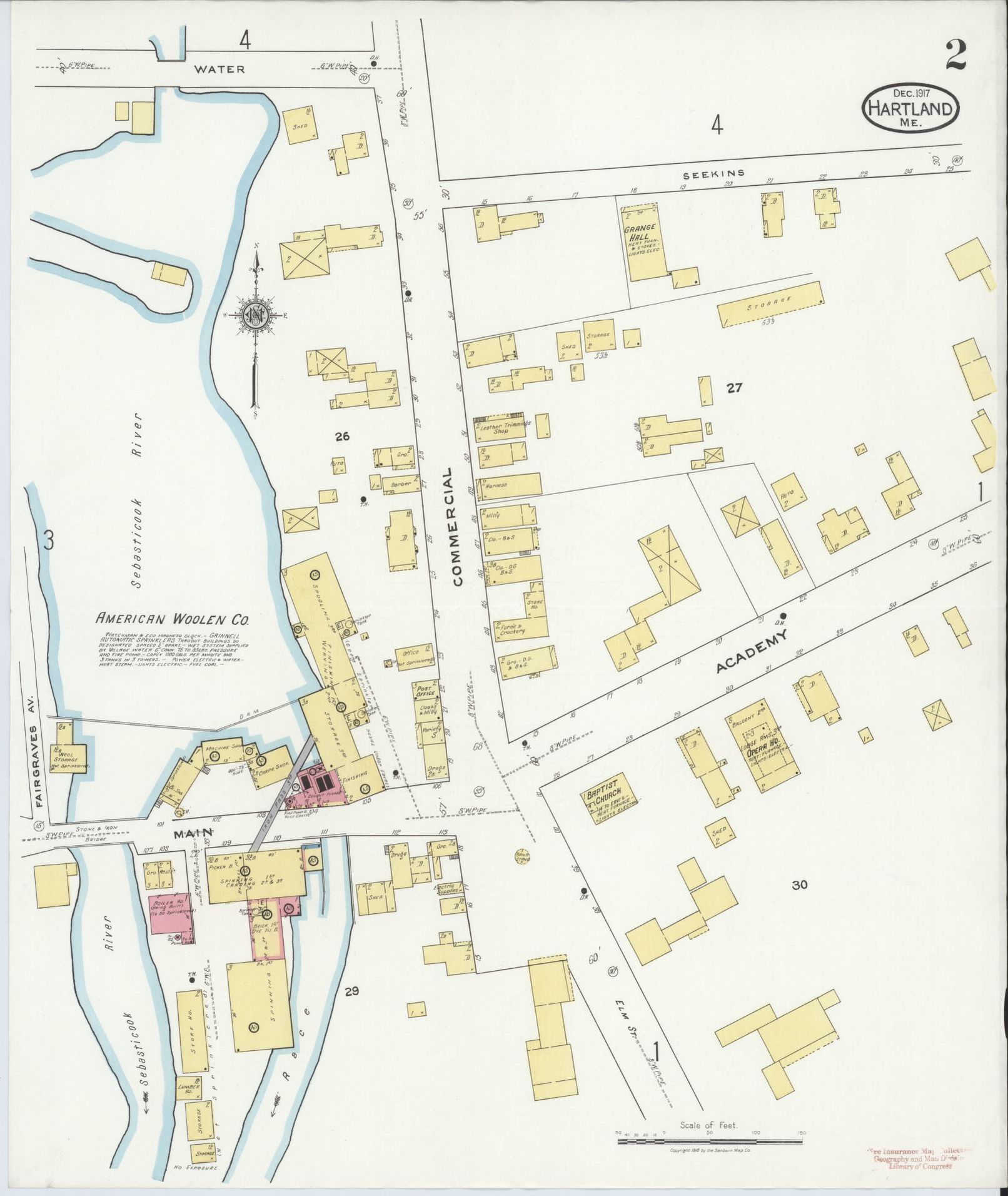
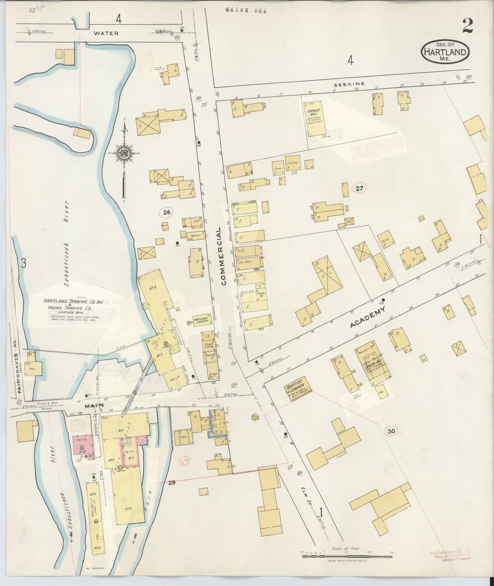
Page 2 – Sanborn Company Fire Insurance Map – 1917
*
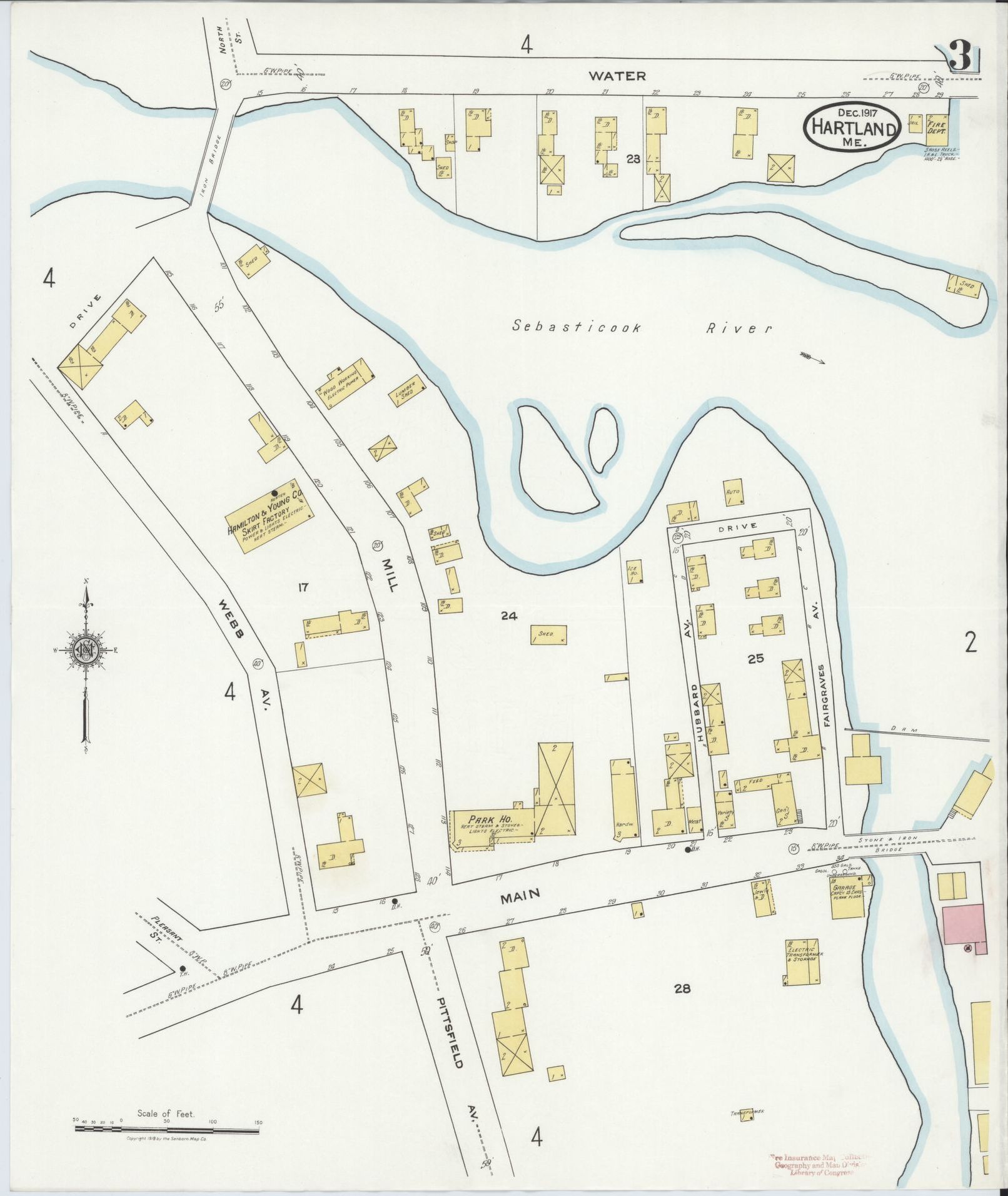
Page 3 – Sanborn Company Fire Insurance Map – 1917
*
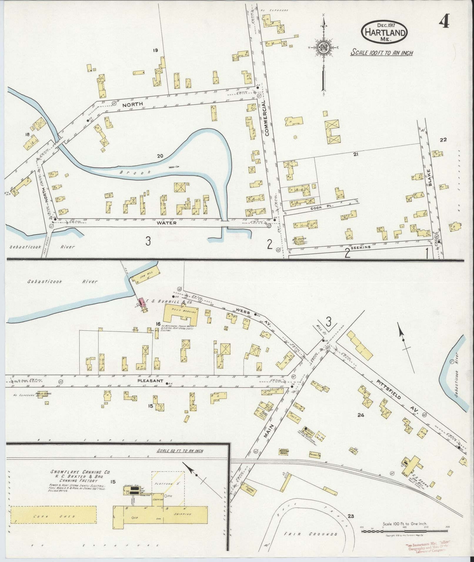
Page 4 – Sanborn Company Fire Insurance Map – 1917
For an enlargeable version of this original map, click the link below:
1917 Sanborn Map at Library of Congress
*
We are in the process of having the 1943 Maps digitally scanned and printed for higher resolution and uniform clarity.
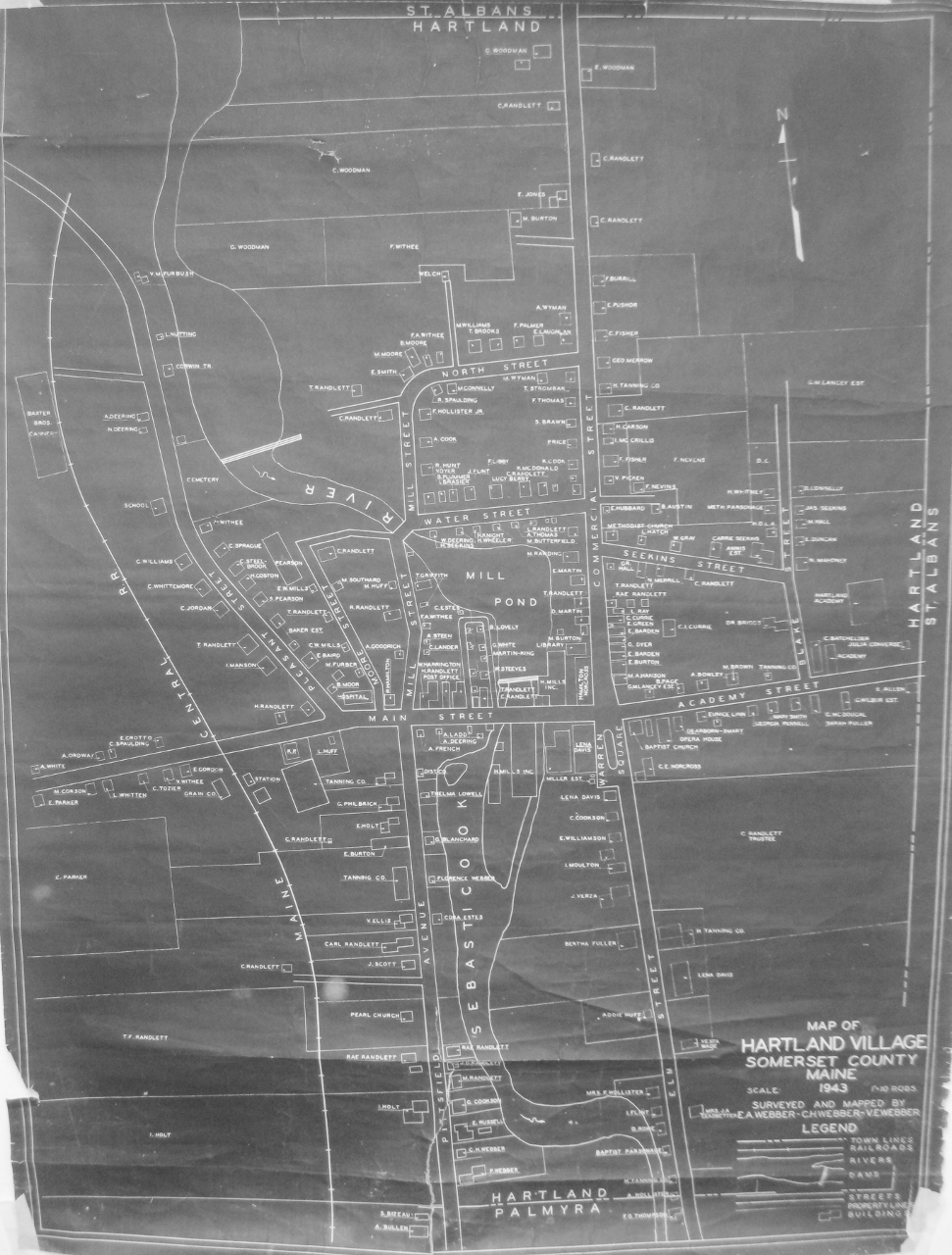
Hartland Village – 1943
*
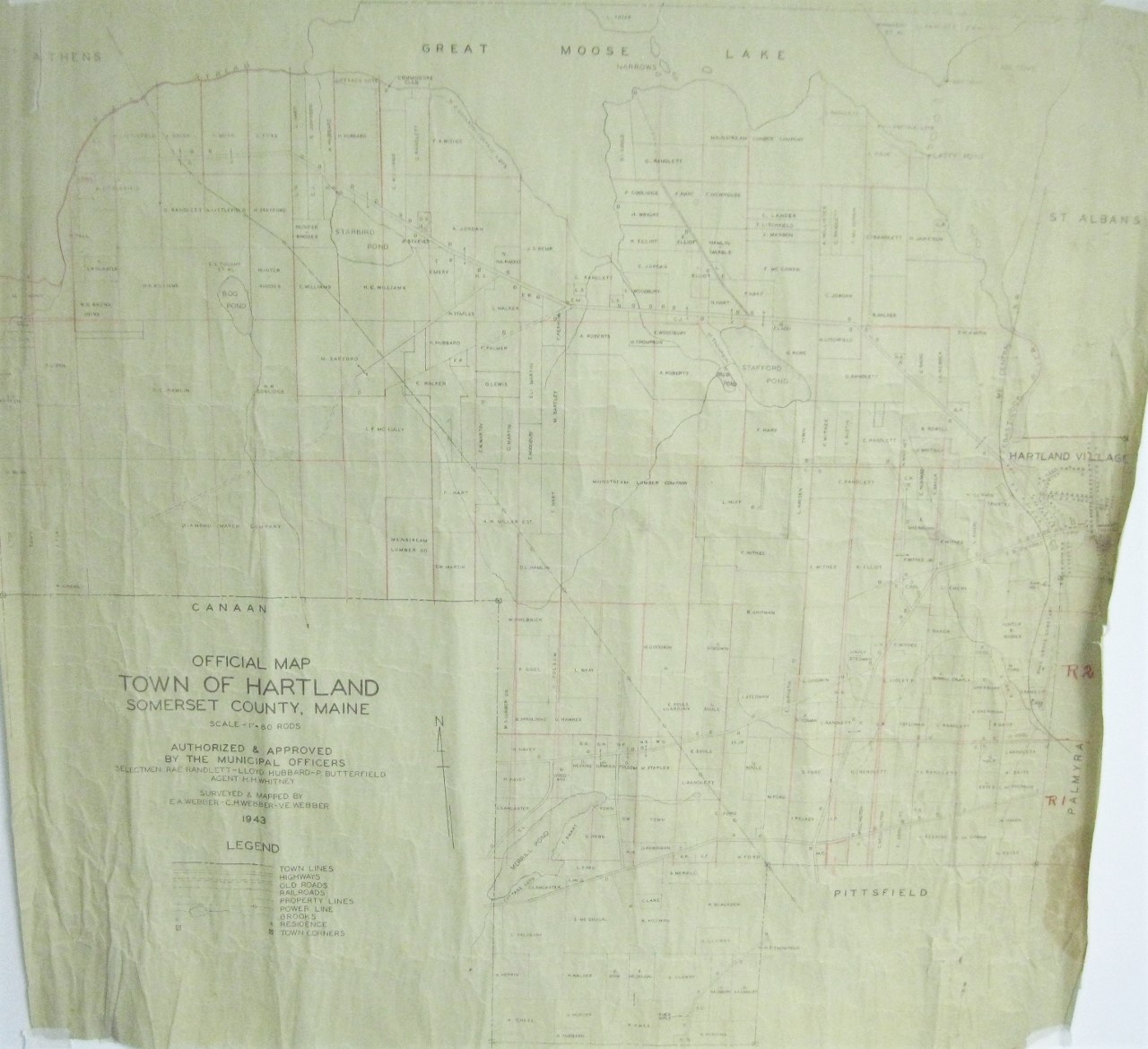
Hartland – 1943
*
In 1945, several revisions were made to the original Sanborn Company Fire Insurance Map of Hartland Village which included new, remodeled or removed buildings and updated business operations since the map’s original publication in 1917.
Page 1 – Sanborn Company Fire Insurance Map – 1945
*
Page 2 – Sanborn Company Fire Insurance Map – 1945
*
Page 3 – Sanborn Company Fire Insurance Map – 1945
*

Page 4 – Sanborn Company Fire Insurance Map – 1945
For an enlargeable version of this original map, click the link below:
1945 Sanborn Map at Library of Congress
*
1982 United States Geographical Survey Topographical Map of Hartland Area.
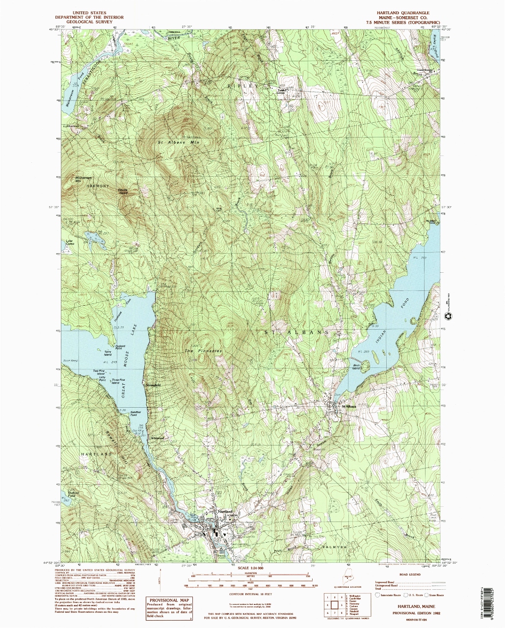
United States Geographical Survey Topographical Map of Hartland Area – 1982
For an enlargeable version of this original map, click on the link below:
USGS Topographical Map of Hartland
*
The Town of Hartland with its current borders in 2024
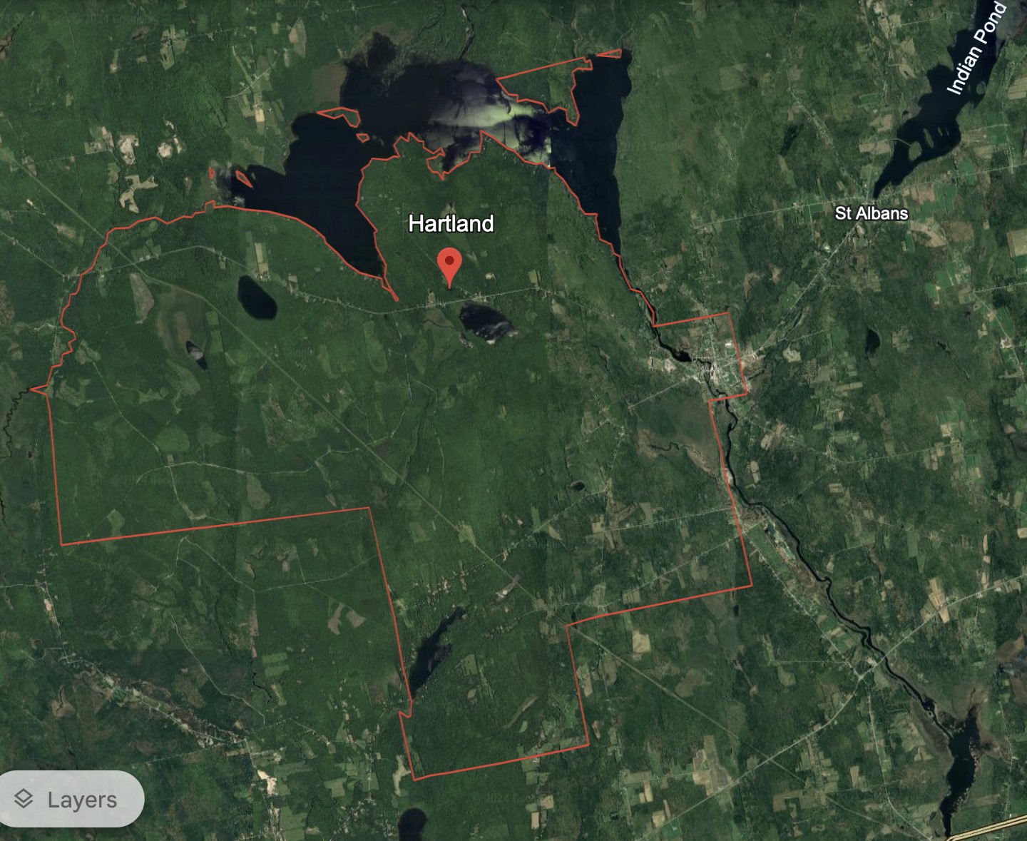
Hartland, Somerset County, Maine – 2024
(Courtesy of Google Earth)