Originally surveyed as Township No. 3 in the 1st Range North of the Plymouth Claim
East of the Kennebec River as part of the Province of Maine of Massachusetts Bay Colony
Known as Warrens No. 3 – Organized October 11, 1819 as a Plantation
Incorporated February 7, 1820 as Town of Hartland, Somerset County, District of Maine, Commonwealth of Massachusetts
*
(Update in progress as of 2/29/2024)
Numerous documents, books, articles and reports relating to Hartland have been discovered over the years and are presented below with many of the documents transcribed from their original source. Our search continues for further information and will be updated as found.
*
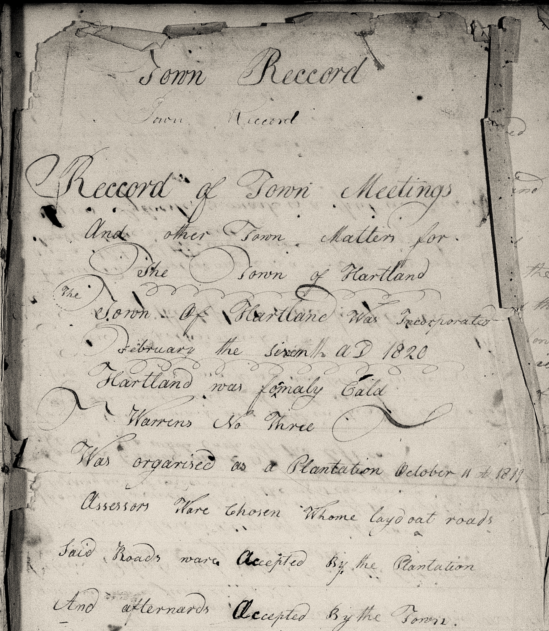
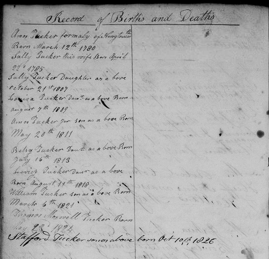
Original Hartland Town Record – 1820
*
~ From a Wilderness Territory to an Incorporated Town ~
In very general terms, the transition from an uncharted territory to becoming an incorporated town in the Commonwealth of Massachusetts followed several procedural steps before being formally recognized as such. Many of these procedures had been in use for many decades before the Revolutionary War when the then Massachusetts Bay Colony formally took over the Province of Maine in 1652 while it was still part of the British colonies and had been applied to many earlier settlements located mostly in Southern Maine and along its coast.
Following the end of the Revolutionary War, the Province of Maine became the District of Maine in the new Commonwealth of Massachusetts in 1780. The inland “wilderness” territories of the now District of Maine were an untapped financial resource for the Commonwealth of Massachusetts dealing with large debts from their part in the Revolution. Developing these vast areas often provided a potential twofold return for the Commonwealth; first when sold to an investor and later from taxes paid by its settlers on their individual lots. They were also a lucrative investment opportunity for many wealthy businessmen to purchase then resell land lots to perspective settlers who in turn eventually incorporated these territories as towns.
*
~ Survey of Lands~
The first step was land surveys done by Surveyors hired on behalf of the Lands Committee which itself was appointed by the General Court of the Commonwealth of Massachusetts, without which no settlement was legal. The Lands Committee held full power and authority to sell and convey unappropriated lands in the District of Maine. Lands so surveyed were divided into ‘Townships’ which, in the Commonwealth, meant areas planned for eventual development into full-fledged towns.
With some exceptions, Surveyors typically mapped out these new townships in relatively squared lots ranging from 28,000 to 32,000 acres. This was standard practice so the Lands Committee could then present the uniform squared lots to potential Land Proprietors for purchase. Albeit convenient for the latter parties, this uniform surveying method often ignored the area’s natural boundaries which later made for problematic access to education, town affairs and services for some of the settlers who came to live there. Almost every new township surveyed would eventually incur necessary adjustments to its original boundaries to accommodate the needs of its settlers including Hartland.
*
* Surveys of Township No. 3 *
The first known official survey map of the region was completed by Ephraim Ballard in September of 1779. Among several future townships noted on Ballard’s map is Township No. 3 in the First Range which eventually became Hartland. A second known survey of the roughly 30,000 acre Township No. 3 Lot was surveyed by Samuel Weston of Canaan in 1790 and 1791 and is referred to in Dr. John Warren’s deed (as the 1792 survey) for the township’s purchase.
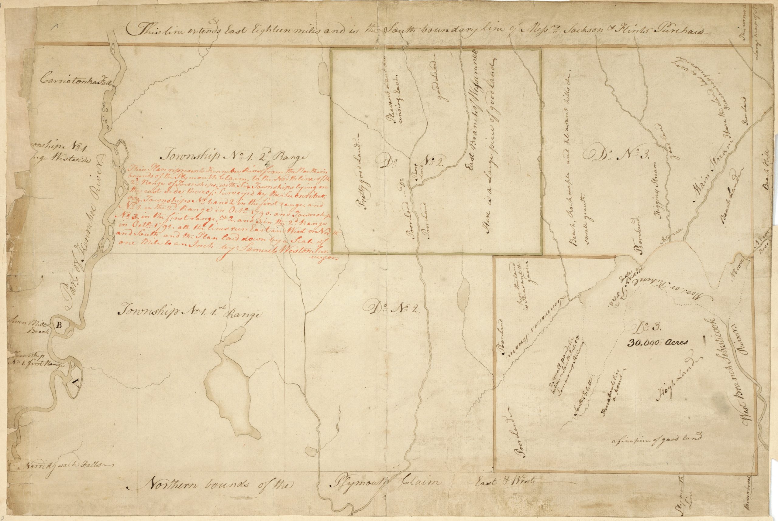
Samuel Weston Survey Map 1790-1791
(Courtesy of Maine State Library | Digital Maine Repository Collection)
For a complete and enlargeable version of this original map, click the link below:
Original Weston Map at Digital Maine Repository
*
Samuel Weston’s original survey of the region from the early 1790s was later redrawn and edited by Carleton Osgood & Co. which added names of the towns as they incorporated. At the time these early surveys were taken, these townships were all still part of Lincoln County before portions of it were established as Kennebec County on February 20, 1799 then subsequently portions of it were formed as Somerset County on March 1, 1809. (See Maps Page for other survey maps)
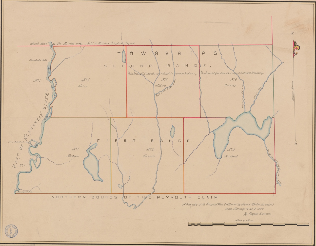
Redrawn & Edited Samuel Weston Survey Map
*
~ Purchase of a Township ~
In most cases, Land Proprietors then bought the newly surveyed townships from the Commonwealth via the Lands Committee. Proprietors were most commonly an individual investor or a group of investors who purchased the land only to resell it to potential settlers without any intentions to personally settle on the land themselves. Not all of these new wilderness townships were purchased by Land Proprietors.
There were no set prices for the purchase of an entire Township. Purchase prices throughout the District of Maine varied greatly due to numerous circumstances such as location, quality of land, accessibility or sometimes just a lack of interest by investors; all of which could influence the final purchase price up or down.
While not as common, due to the substantial cost of purchasing a Township, a few townships were purchased by groups of people who pooled their resources and became Co-Proprietors of the Township with specific intentions to settle on the land. Often these groups of investors shared common interests such as being part of a particular religious congregation or a group of extended family members.
*
* Deed for Township No. 3 to Dr. John Warren – June 15, 1799 *
Know all men by these presents that we whose names are undersigned and seals are hereunto affixed, appointed as Committee by the General Court of the Commonwealth of Massachusetts, with full power & authority, to sell and convey the unappropriated lands of said Commonwealth, lying within the District of Maine, in consideration of Eight Thousand, One Hundred and Forty Nine Dollars and Thirty Cents, to us in hand paid by John Warren of Boston in the County of Suffolk of the Commonwealth of Massachusetts, Physician, for the use of said Commonwealth, the receipt whereof we do hereby acknowledge, have given, granted, sold and conveyed, and by these presents, in behalf of said Commonwealth, do give, grant, sell and convey unto the said John Warren, assignee of Moses Barnard and Joseph Hilton both of Deerfield, & Isaac Thom & George Reid both of Londonderry, and all of the State of New Hampshire, Esquires, and their associates, a township of land lying in the County of Lincoln, and containing about Thirty Thousand Acres, be it the same or more of 1%, the said Township being Number Three (Hartland) in the First Range, north of the Plymouth Claim, on the east side of the Kennebec River, as the same was surveyed by Samuel Weston in the year Seventeen Hundred & Ninety Two; bounded easterly by Number Five (St Albans) in the Fourth Range north of the Waldo Patent, in part; and partly by Township Number Five (Palmyra) in the Third Range above said patent; southerly by the Township (Palmyra) last mentioned, in part, and partly by the Plymouth claim; westerly by Township Number Two (Cornville) in the First Range north of the Plymouth claim; and northerly by Township Number Two (Athens) in the Second Range north of the Plymouth claim, in part, and partly by Township Number Three (Harmony) in the range last mentioned, and by Moose or Pickerel Pond.
Excepting and reserving however, four lots of three hundred and twenty acres each for the following uses viz.; One lot for the first settled Minister, his heirs or assigns – One lot for the use of the Ministry – One lot for the use of schools – One lot for the future disposition of the General Court. The said lots to average in situation and quality with the other lands in said Township.
To have and to hold, the above granted Premises with the appurtenances thereof to the said John Warren, his heirs or assigns forever, on condition that the said John Warren, his heirs or assigns shall grant and convey to each settler in said Township, who settled therein, before the First day of January, Seventeen Hundred and Eighty Four, or in case of his decease without assignment, then to his heirs and in case of assignment, then to the assigns, One hundred acres to be so laid out, as will best include the improvements of the settler, and be least injurious to the adjoining lands, so as that the settler, his heirs or assigns may hold the same in fee simple.
Provided that the settler his Heirs or assigns shall within one year after notice and request, pay to the grantees named in this Deed, their heirs or assigns, Five dollars, and on this further condition, that the said John Warren, before the twentieth day of June, One Thousand Eight hundred and One, shall settle twenty families within said township, and before the twentieth day of June, One Thousand Eight hundred and Five shall settle twenty families more.
And the said committee covenant with the said John Warren, that the said Commonwealth shall warrant and defend the above granted premises to him, the said John Warren, on the said condition and saving the reservations aforesaid, to him his heirs and assigns forever; against the lawful claims and demands of all persons; the above granted Township having been contracted for, by the said Moses Barnard, Joseph Hilton, Isaac Thom and George Reid and their associates, on the Twenty Sixth day of February One Thousand Seven Hundred and Ninety Six.
In witness whereof, we have hereunto set our hands and seals, this Fifteenth day of June, in the year of our Lord, Seventeen Hundred and Ninety Nine.
Signed, Sealed & Delivered in presence of:
Nathaniel L. Wells – Leonard Jarvis – John Read, Sr – John Vinall – John Read, Jr
Boston, Suffolk County, Commonwealth of Massachusetts – June 15, 1799
Personally appeared the above named Nathaniel L. Wells, Leonard Jarvis & John Read acknowledged this instrument to be their free act and Deed before John Vinall, Justice of the Peace
*
Dr. John Warren was born and raised in Roxbury, Massachusetts. He graduated in 1771 from Harvard University and in 1777 married Abigail Collins with whom he had 17 children. He served as a Surgeon in the Revolutionary War along with his brother Dr. Joseph Warren who was killed at The Battle of Bunker Hill. John was well known for his accomplishments in the Boston area as a physician, anatomist, surgeon, and medical educator as well as founding the Harvard Medical School in 1782.
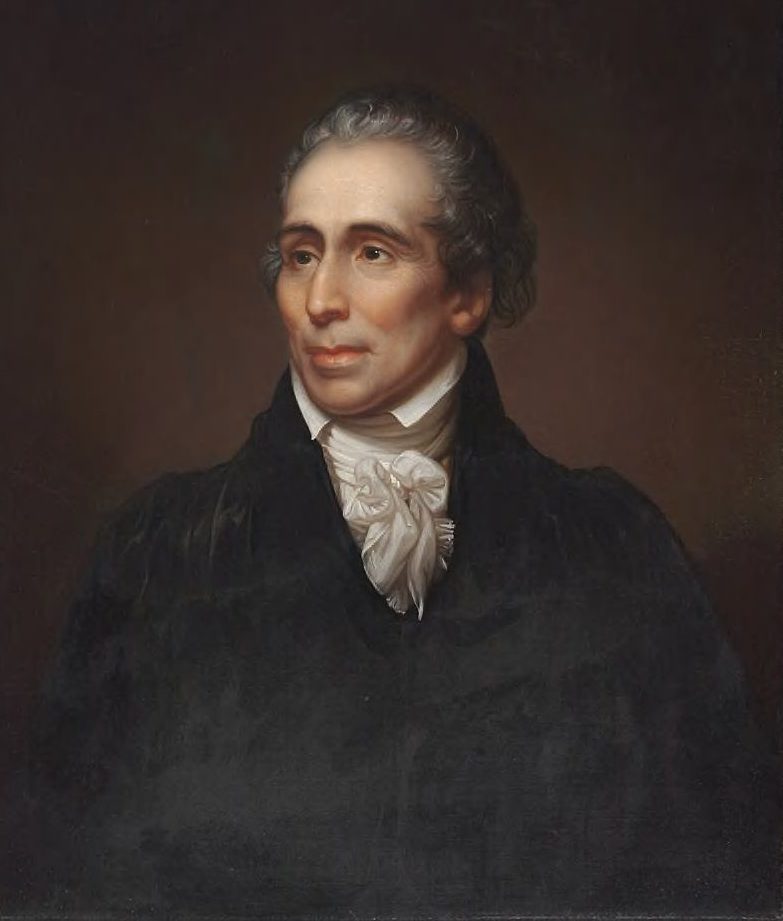
Dr. John Warren (1753-1815)
*
~ “Warren’s Four Towns” ~
Along with his purchase of Township No. 3 in the 1st Range (Hartland), Dr. Warren bought Township No. 5 in the 4th Range (St Albans) in 1799, Township No. 5 in the 3rd Range (Palmyra) in 1800 and Township No. 4 in the 4th Range (Corinna) in 1804, the latter 3 surveyed as north of the Waldo Patent. These 4 townships, often referred to collectively as “Warren’s Four Towns”, would be historically interwoven with numerous family connections between them over the decades.
*
~ “Planting” a Township ~
The Proprietors who purchased townships as investments then typically had the land divided up into various sized lots ranging anywhere from 50 acres to 400 acres with varying prices depending on the size of the lot and/or its location; for example a prime 100 acre lot on a lush river bank versus a 100 acre barren, rocky hillside lot.
Many Proprietors advertised their available lots in newspapers or bulletins throughout Southern Maine, New Hampshire and Massachusetts in an attempt to ‘plant’ their township by luring people with the opportunity of ‘cheaply’ owning their own land and beginning a new life. Word of mouth passed along by early settlers could also encourage other family members, friends or former neighbors to join them at the new township.
Planting their new township with settlers was critical to the Proprietor’s return on investment as they were immediately responsible to pay taxes on the land and conform to certain Rules of Settlement. The more settlers who could be instead taxed directly by the Commonwealth of Massachusetts meant less taxes paid by the Proprietor.
No matter the type of Proprietor, the Rules of Settlement of the General Court of the Commonwealth of Massachusetts required certain stipulations for settlement of any Township such as specific amounts of prime land reserved for a church, a minister, meeting house and a school. Another stipulation was a certain amount of settlers to the township over the course of a certain time period such as 20 settlers within 2 years and 40 settlers within 7 years as noted in Dr. Warren’s deed for Township No. 3.
*
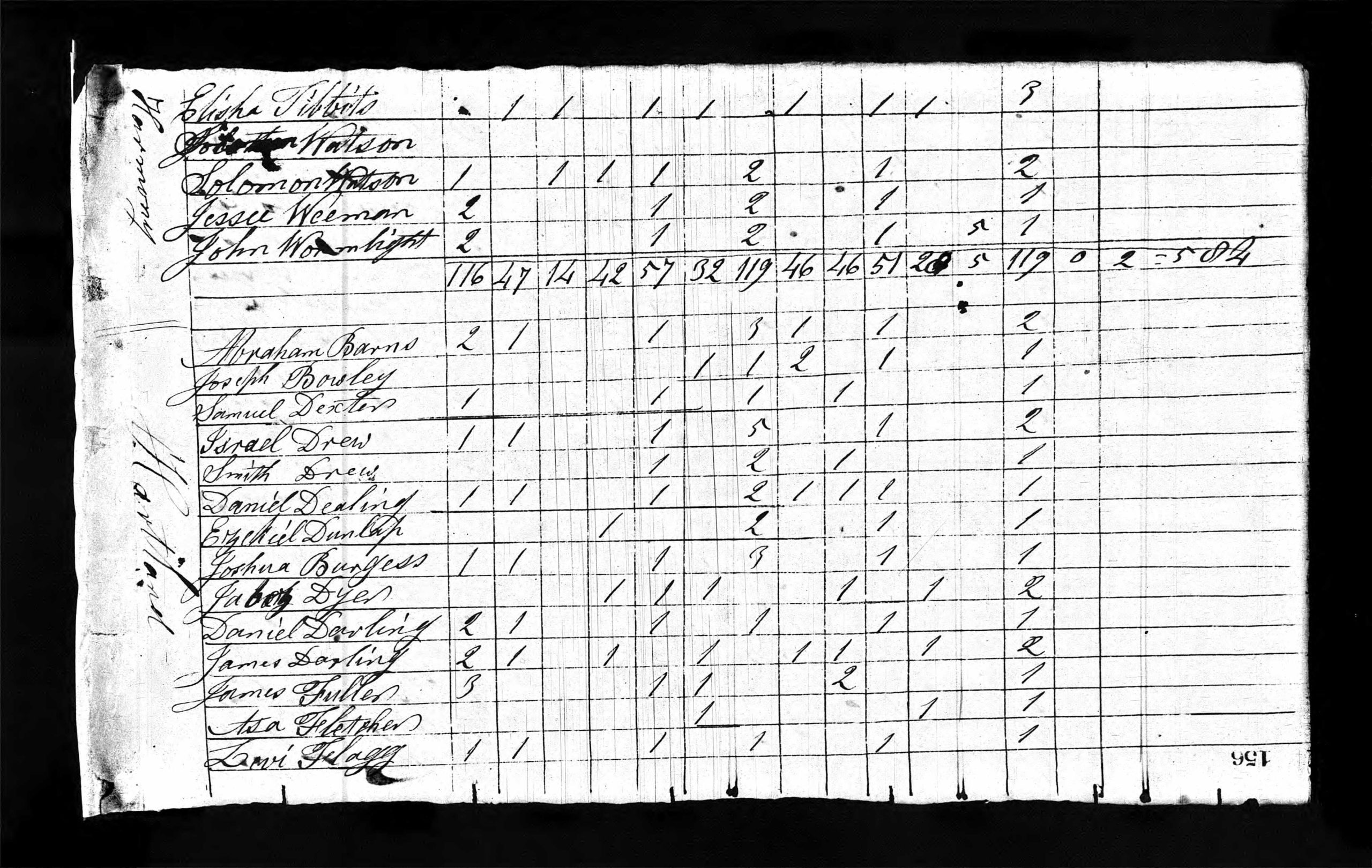
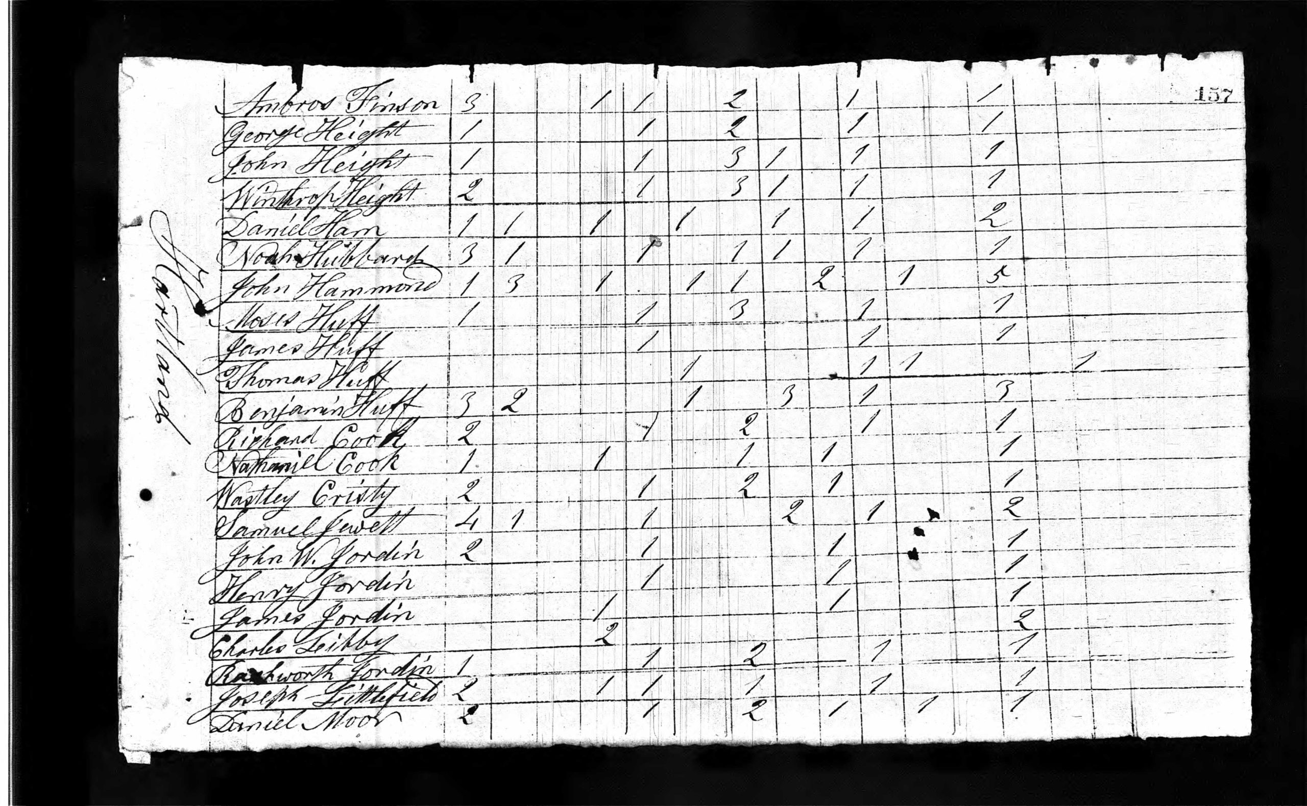
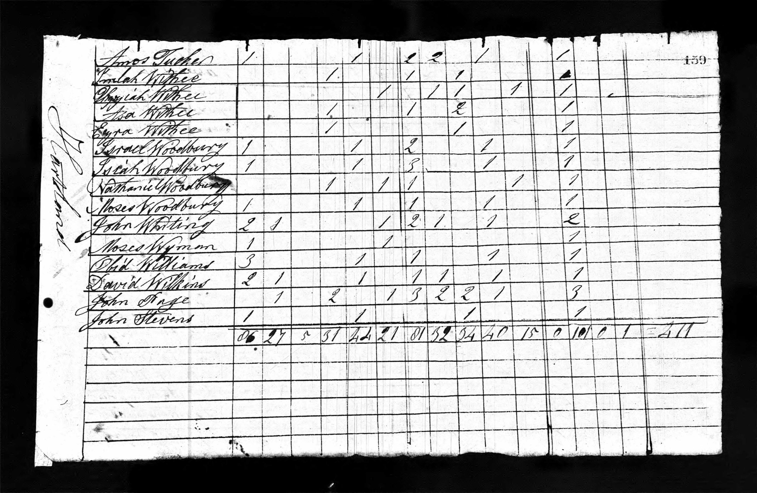
* 1810 United States Federal Census *
As there were no known permanent settlers in Township No. 3 at the time the 1800 U. S. Census was taken, 1810 was the first Census that included some of the families who had settled around parts of the future West Hartland & North Hartland regions since 1802. It will be noted a few families known to have been living in the area, such as James Fuller Sr, are not noted on these 2 particular Census pages below and may have been missed or are listed on another sheet. Our search continues for those additional listings if they exist. Portions of nearby Townships are also seen on the pages.
*
The official enumeration day of the 1810 census was August 6, 1810. All questions asked, such as ages, were supposed to refer to that date. The enumeration was to be completed within nine months, but the due date was extended by law to ten months.
Enumerators of the 1810 Census were asked to include the following categories in the census: name of head of household; number of free white males and females in age categories: 0 to 10, 10 to 16, 16 to 26, 26 to 45, 45 and older; number of other free persons except Indians not taxed; number of slaves; and town or district and county of residence.
The categories allowed Congress to determine persons residing in the United States for collection of taxes and the appropriation of seats in the House of Representatives. Most entries were arranged in the order of visitation, but some were rearranged to appear in alphabetical order by initial letter of the surname. (Compiled from Ancestry)
*
The top of Census form included Page Number, State, County, Call Number & Enumeration Date.
- Location (Town or Township)
- Name of Head of Family
- Free white males under ten years
- Free white males of ten and under sixteen
- Free white males of sixteen and under twenty-six, including heads of families
- Free white males of twenty-six and under forty-five, including heads of families
- Free white males of forty-five and upwards, including heads of families
- Free white females under ten years
- Free white females of ten and under sixteen
- Free white females of sixteen and under twenty-six, including heads of families
- Free white males of twenty-six and under forty-five, including heads of families
- Free white females of forty-five and upwards, including heads of families
*
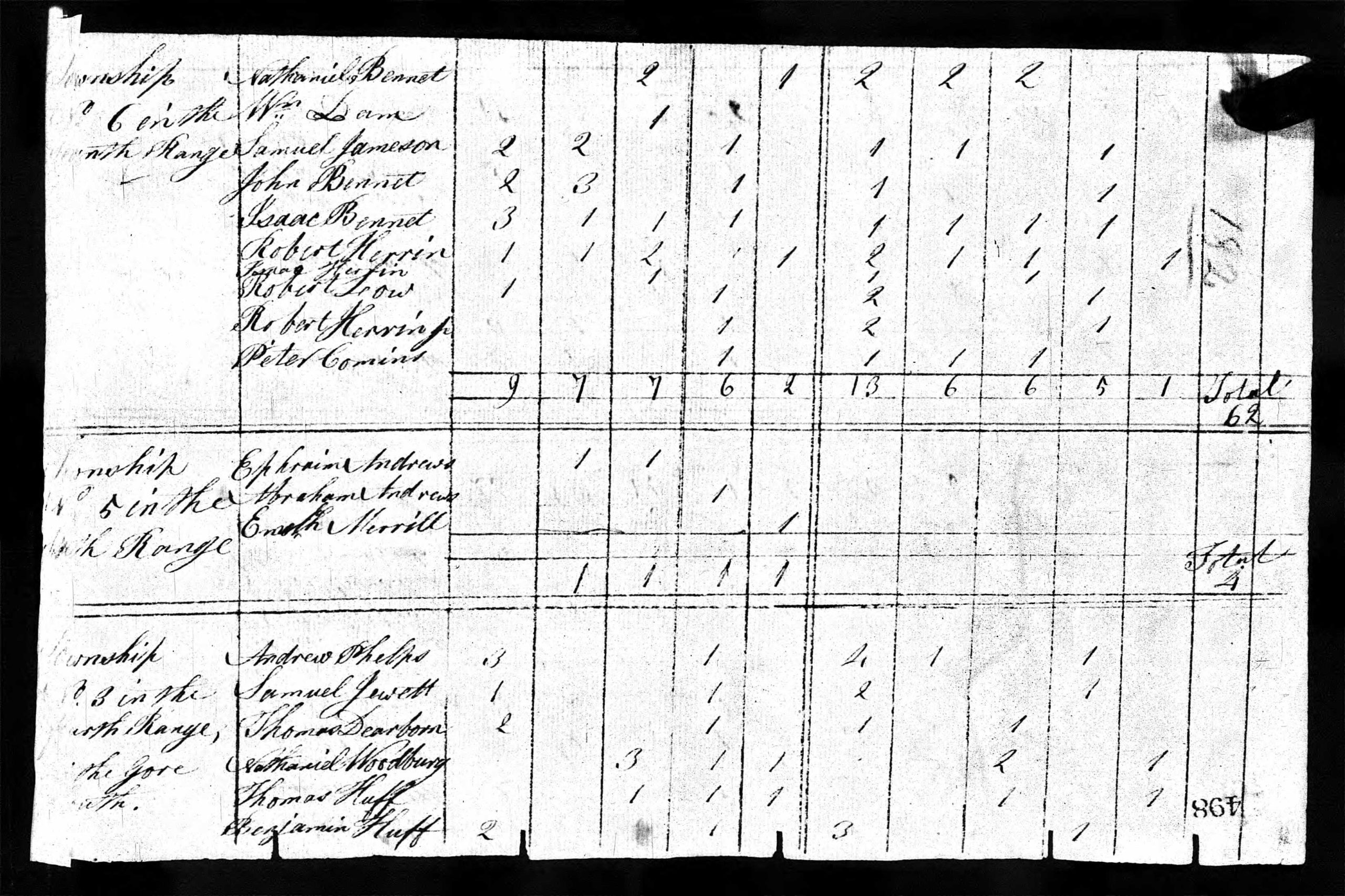
1810 U. S. Federal Census – Township No. 3 – Fourth Range – Page 1 (Bottom Section)
*
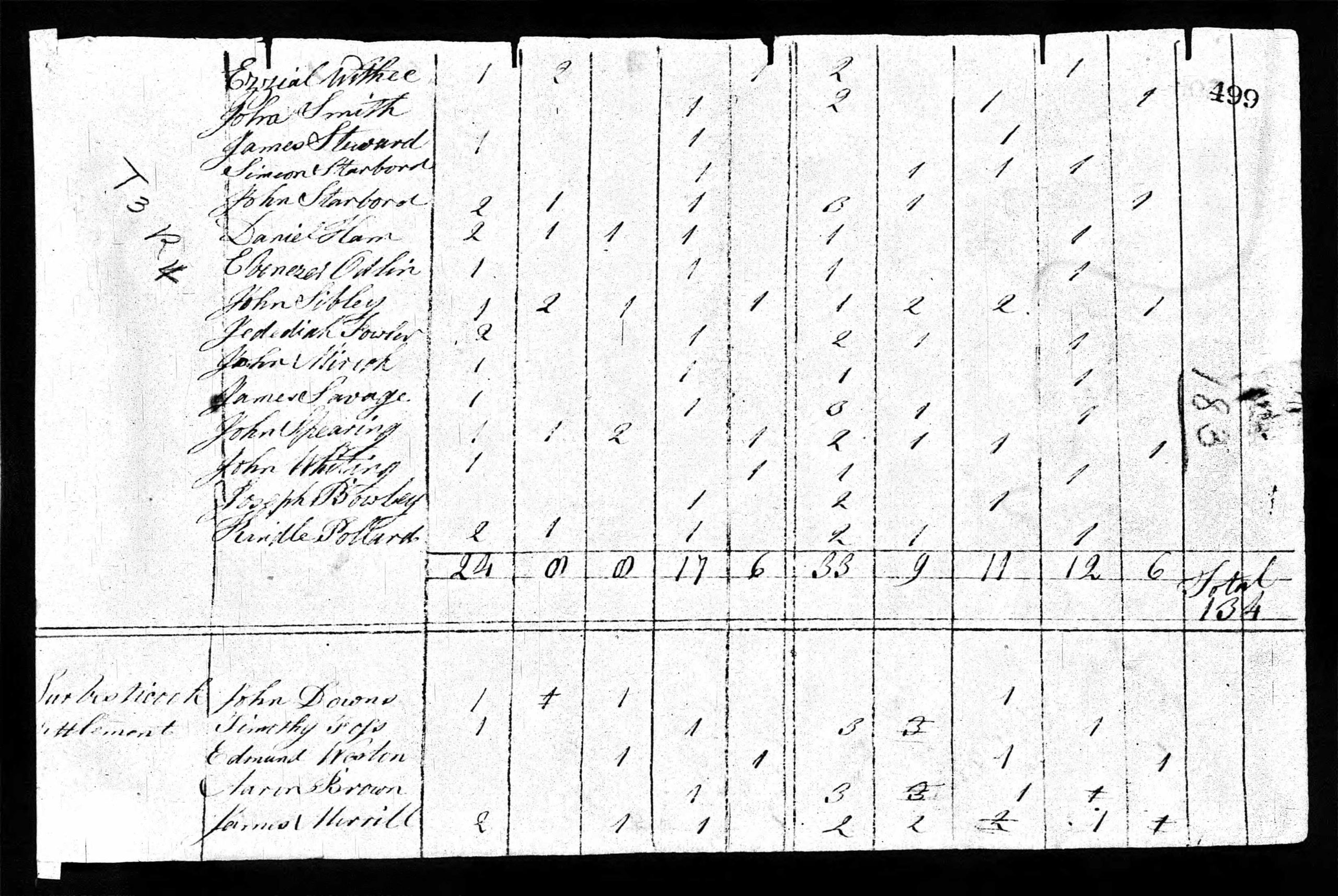
1810 U. S. Federal Census – Township No. 3 – Fourth Range – Page 2 (Top Section)
*
~ Township No. 5 – Fairhaven ~
Before it existed as what we know today as Hartland Village, the area on the eastern side of the West Branch of the Sebasticook River as well as a sizable portion of land along the western side of the river was originally part of Township No. 5 in the 4th Range North of the Waldo Patent which eventually incorporated as the Town of St Albans on June 14, 1813.
Many years before settlement began in the present St Albans Village area, early pioneers of Township No. 5 first settled around St Albans Mountain including Judah Hackett who was the first to settle there in 1800. In 1802, William Moor and his wife Sally brought their family to permanently settle at their home on present day Commercial Street in Hartland located on part of his large lot in Township No. 5 he had purchased earlier which spanned along both sides of the Sebasticook River.
The early settlers of Township No. 5 referred to the area as “Fairhaven”. Although Fairhaven began as part of Township No. 5, the boundaries of Hartland and St Albans near and around the Sebasticook River area would become a long and sometimes controversial debate for several decades with a couple of line fluctuations made and then later some unmade from their original surveyed township lines.
As St Albans’ population shifted in the early 1820s to the St Albans Village area at the foot of Big Indian Pond, its town affairs also centralized there. Those citizens still living near the Sebasticook River area were further distanced from participation and representation in matters of taxation, schools, roads and other St Albans town affairs. Up until the present day town lines between the two were established in 1846, a large part of the future Hartland Village area remained split as 2 towns served by 2 town governments.
*
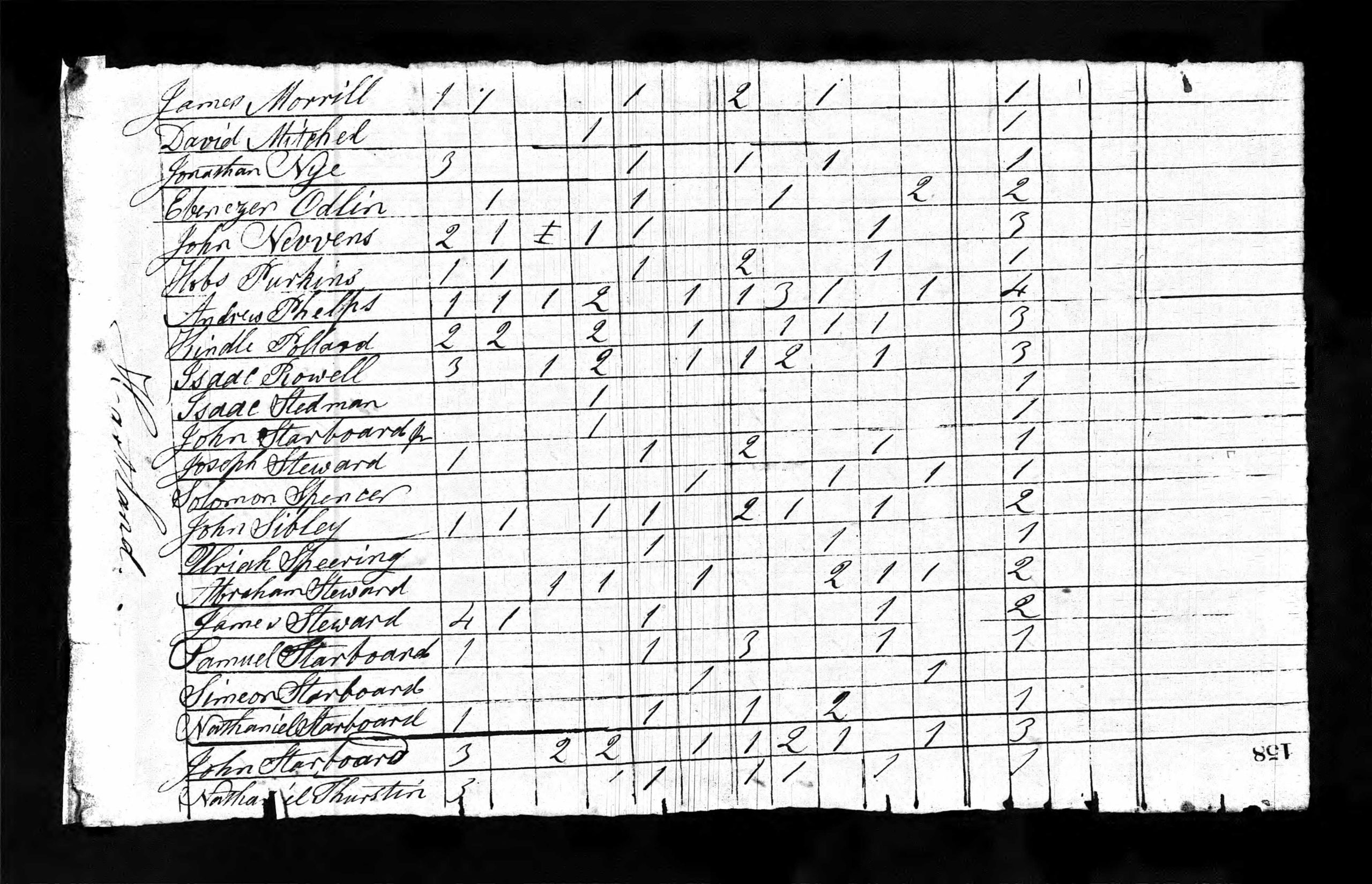
By the time the 1810 U. S. Federal Census was taken for Fairhaven, so called, some 2 dozen families totaling 187 people had already settled around the area. This included William Moor and family members of his wife Sally Moor including her father Abraham Moor and her brother Samuel Moor.
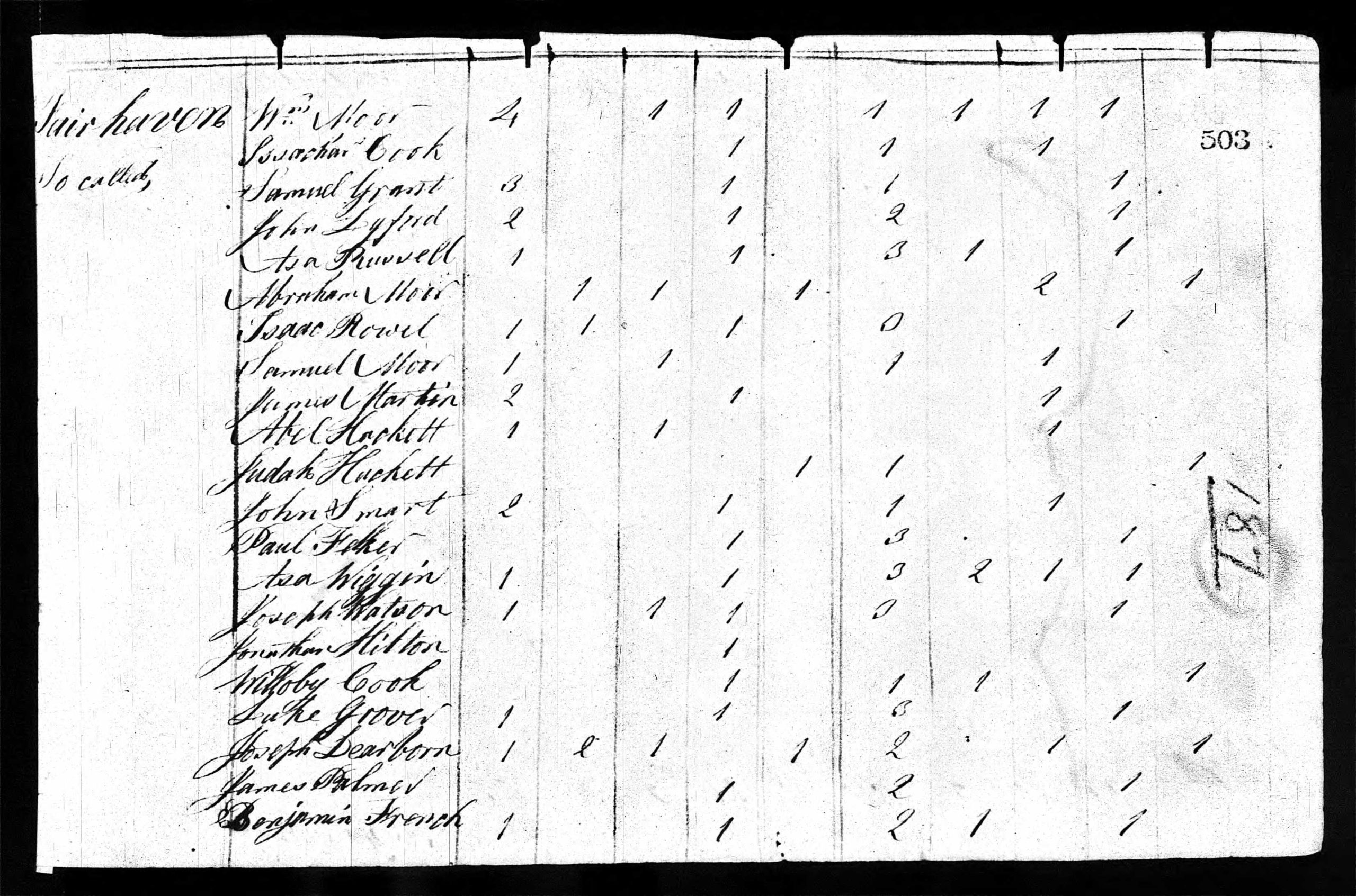
1810 U. S. Federal Census – Fairhaven
Transcription of the 1810 Census for Fairhaven as listed in order by Head of Household:
William Moor | Isachar Cook | Samuel Grant | John Lyford | Asa Rowell | Abraham Moor | Isaac Rowell | Samuel Moor | James Martin
Abel Hackett | Judah Hackett | John Smart | Paul Felker | Asa Wiggin | Joseph Watson | Jonathan Hilton | Willoby Cook
Luke Grover | Joseph Dearborn | James Palmer | Benjamin French
*
~ Warrens No. 3 / Warren Town No. 3 ~
Sometime after 1810, the settlers of Township No. 3 began to refer to their township as Warrens No. 3 as noted in the original 1820 Hartland Town Record seen above. Alternative town titles of Warren Town No. 3 or Warrenstown No. 3 are also mentioned in other documents.
*
~ From Township to Plantation ~
Township status meant it was recognized but held no formal organizational legal powers over its land use or its settlers nor was it represented in the Commonwealth of Massachusetts Legislature. Although it was not a mandated step in the process to incorporation, some townships organized as a ‘Plantation’ once enough settlers had located there. Plantation status granted some very limited self-government but still provided no legal means to raise money for the support of schools or the making or repairing of roads, etc. Nor did a Plantation status provide representation in the Commonwealth Legislature. At no time in the history of the Province or District of Maine had it been required that a plantation become a town, nor that a town should have a previous existence as a plantation.
*
* Organizing Township No. 3 as a Plantation *
(Information Pending further research details)
*
~ Incorporating as a Town ~
As the population of a Township or Plantation continued to grow, the lack of self-governing powers or even limited self-governing powers, neither with a legal means to raise money, perpetuated itself into larger issues for its settlers wishing to move forward with plans for their town’s growth and development.
In order to eliminate these set restrictions or limitations of local self-governing, townships would attempt to become an incorporated town. In order to do so, the inhabitants of a Township or Plantation first had to formally petition the Commonwealth of Massachusetts General Court with their literal pleas as to why they should be incorporated as a Town as well as provide ample and qualified signatures; the latter being only free white males over 18 years old.
It seems likely, but unconfirmed, the undated petition below was created sometime in late 1819 as it would have taken some amount of time to first write it and then gain ample signatures by its qualified settlers with some probably signing it at a special Town Meeting. It then had to be sent on its slow trip to Boston for consideration by the next upcoming assembly of the Commonwealth of Massachusetts General Court which was held from January 12, 1820 thru February 25, 1820.
This document is also the first time the name of the township is referred to in records as Hartland. While several theories exist, documented origins of the selected town name of Hartland remain unknown.
*
* Petition to Incorporate the Town of Hartland – 1819 *
To the Honorable Senate and House of Representatives of the Commonwealth of Massachusetts in General Court;
We, your petitioners, inhabitants of Township No. Three, so called, bounded West by Cornville, North by Athens and Harmony, East by St. Albans and Palmyra and South by the Ell of Palmyra and the Mile and a Half Strip, so called, humbly represent that there is upwards of fifty families in said Township, and that we labor under many and great inconveniences whereby we cannot in our present situation by any legal means raise money for the support of schools or the making or repairing of roads. We therefore pray your honors to incorporate said Township in a town by the name of Hartland, and as in duty bound we pray.
Signed,
Thomas Smith Abraham Steward Wesley Christy Isaac Rowell John Davis Samuel Jewitt James Stewart Ezra Withee (Sr)
Uzziel Withee Solomon Spencer Asa Withee James Darling J. Withee Hobbs Perkins George Fuller James Fuller (Sr)
Ambrose Finson Ezekiel Dunlap Joseph Steward Jed Hammond Levi Flagg John Hammond William Fa _ _ th Andrew Phelps
Joseph Phelps John Smith Thomas Huff Benjamin Huff James Huff Moses Huff John Spearin Isaiah Woodbury (I)
Joseph Bowley Uriah Spearin Amos Tucker David Mitchell James Jordan Richard Cook Nathaniel Thurston
*
* An Act to Incorporate the Town of Hartland – 1820 *
Commonwealth of Massachusetts – In the Year of our Lord, One Thousand Eight Hundred and Twenty
Be it enacted by the Senate and House of Representatives in General Court assembled and by the authority of the same, that the Township Numbered Three in the County of Somerset commonly called Warren Town, as described by the following boundaries be and hereby is incorporated and established as a town by the name of Hartland; west by Cornville; north by Athens and Harmony; east by St. Albans and Palmyra; southerly by the L of Palmyra, so called; thence from the west line of said L to the southeast corner of Cornville, including the Mile and a Half Strip.
And the inhabitants of the said town of Hartland are hereby vested with all the corporate powers and privileges and shall be also subject to the like duties and requisitions of other corporate towns according to the Constitution and laws of this Commonwealth and any Justice of the Peace for the County of Somerset is hereby empowered upon application therefor to issue a warrant directed to a freehold inhabitant requiring him to notify and warn a meeting of the freeholders and other inhabitants of the said town of Hartland to meet at such convenient time and place as shall be appointed in said warrant for the choice of such officers as towns are by law empowered and required to choose at their annual town meetings.
Alden Bradford
Secretary of the Commonwealth of Massachusetts
*
Passed by the Massachusetts House of Representatives | February 4, 1820
Passed by the Massachusetts Senate | February 5, 1820
Approved by Massachusetts Governor John Brooks | February 7, 1820
*
A handwritten copy, as transcribed above, of the 1820 Act of Incorporation from Hartland Vital Records signed & noted as a true copy by Secretary of the Commonwealth of Massachusetts Alden Bradford and attested as such by Hartland Town Clerk Ambrose Finson.
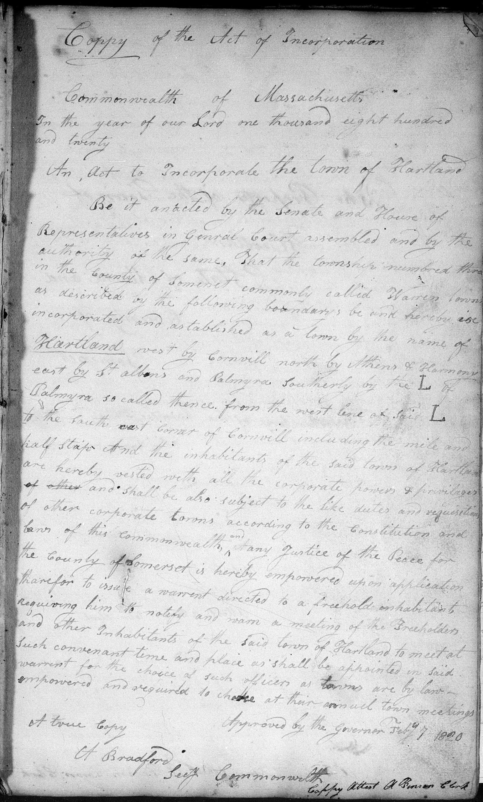
An Act to Incorporate the Town of Hartland
*
~ Town of Hartland – Somerset County – District of Maine – Commonwealth of Massachusetts ~
Hartland thus became the 235th Town in the then District of Maine of the Commonwealth of Massachusetts on February 7, 1820. It would be the next to last town to incorporate under the Commonwealth of Massachusetts before Maine became a State on March 15, 1820 with Etna being the last on February 15, 1820.
*
The Act to Incorporate the Town of Hartland as recorded by the Massachusetts General Court may be seen on the link below:
*
Laws of the Commonwealth of Massachusetts
~ Hartland Vital Records ~
A number of original Hartland Vital Records from 1820 to 1891 have been digitally scanned on the Family Search Website. Not EVERY record from these years is contained but there are many birth and marriage records along with early Town Meeting Reports. You will need an existing account or you need to create a new account to view these records, but it is a FREE site to join. Instructions to access the file are noted below.
- Once you are signed in, click on SEARCH on the toolbar on top of the Home Page.
- Select IMAGES from the pull down menu, then type in Hartland, Maine in the SEARCH BOX.
- Click on the file name Hartland, Maine, Somerset County, United States, then hit SEARCH IMAGE GROUPS.
- Click on the “1 result” for the 319 pages of 1820-1891 Vital Records of Hartland to open the file.
- Page 7-30: Alphabetical Surname Listing (Mostly 1880s Children – Unknown random report)
- Page 34-44: Delayed Birth Certificates from late 1800s filed between 1934-1953
- Page 50-113: Town Reports from 1820-1829
- Page 114-116: Recorded Marriages from 1820-1827
- Page 117-128: Family Lineages done between 1820-1832 including children names and birth dates
- Page 134-224: Recorded Marriages from 1840-1869
- Page 230-317: Recorded Marriages from 1869-1891
Sample Page of Family Lineages from Hartland Vital Records
*
~ The Rights & Duties of an Incorporated Town ~
As a newly incorporated Town of the Commonwealth of Massachusetts, Hartland received full self-organizational powers to perform various mandated duties of a town. Those duties included a required town meeting to select various officers and begin legally raising monies to support various endeavors within its town limits. The new town also gained all associated Civil Rights of the Commonwealth and, of equal importance, automatically allotted one Representative in the Massachusetts Legislature.
*
* Warrant for the 1st Hartland Town Meeting – March 3, 1820 *
To Ambrose Finson, Esquire – Town of Hartland
You are hereby required in the name of the Commonwealth of Massachusetts to summons and notify the freeholders and other inhabitants of said town qualified by law to vote in town meetings viz; such as pay to one single tax besides the Poll or Polls a sum equal to two thirds of a single poll tax, to assemble at Joseph Stewards on Monday the Thirteenth day of March at Ten of the clock in the forenoon to act on the following articles, viz;
1. To choose a Moderator
2. To choose a Town Clerk
3. To choose Selectmen and Assessors
4. To choose a Town Treasurer
5. To choose Surveyors of Highways
6. To choose Surveyors of Boards
7. To choose Fence Viewers
8. To choose one or more Tythingmen
9. To choose a Committee to district the town into Highway and School Districts
10. To choose a Pound Keeper
11. To choose Field Drivers
12. To choose a Collector of Taxes
13. To choose a Constable.
And all other business the town thinks proper.
Given under my hand seal this Third day of March 1820
William Moor – Justice of the Peace (seal)
Pursuant to the within warrant I have summoned and notified the inhabitants of said town qualified as there in expressed to assemble at the time and place and for the purpose within mentioned.
(signed) Ambrose Finson
*
* 1st Hartland Town Meeting – March 13, 1820 *
At a legal meeting of the inhabitants of the Town of Hartland, March 13th, 1820, verbally warned for the purpose of choosing Town Officers for the present year. Agreeable to an act of Incorporation granted by the Massachusetts General Court, February 7th, 1820.
- Voted – Ambrose Finson Moderator
- Voted – Ambrose Finson Town Clerk (Oath administered by William Moor, Justice of Peace)
- Voted – Ambrose Finson First Selectman
- Voted – Isaac Rowell Second Selectman
- Voted – Ebenezer Odlin Third Selectman
- Voted – Ambrose Finson, Isaac Rowell and Ebenezer Odlin Assessors of Taxes
- Voted – James Steward Town Treasurer
- Voted – Isaac Rowell and Ebenezer Odlin Surveyors of Boards
- Voted – Joseph Steward, David Wilkins and Joseph Bowley Fence Viewers
- Voted – Amos Tucker, David Wilkins and John Nevens Tythingmen
- Voted – Ambrose Finson Pound Keeper
- Voted – Henry Jordan, John Nevens and Nathaniel Starbird Field Drivers
- Voted – Joseph Steward Constable
- Voted – That the lowest bidder shall collect the taxes. Joseph Steward bids four cents on the dollar which is the lowest bid. Voted to accept Ambrose Finson and James Steward, bondsmen for Joseph Steward, Collector of Taxes.
The several Town Officers chosen at this meeting had the oath of their respective offices administered by Benjamin French in presence of the meeting.
Submitted by Ambrose Finson, Town Clerk
*
~ Town of Hartland – Somerset County – State of Maine – March 15, 1820 ~
The first Hartland Town Meeting held on March 13th was also their last as a part of the Commonwealth of Massachusetts when Maine was inducted as a new State in the Union on March 15, 1820. As was the case throughout the former District of Maine, those rights and privileges of incorporation granted by the Commonwealth of Massachusetts, from the 1st of Kittery in 1652 to the 236th of Etna in 1820, were transferred to the new State of Maine. This included a Representative in the Maine State Legislature which the citizens of Hartland elected Ambrose Finson to first fulfill the position.
*
In the early years of the town, it was common practice to hold several Town Meetings in a single year. Typically, the first meeting was held to go over all proposed articles followed up by further meetings to vote on specific items as seen below.
*
* Hartland Town Meeting – April 3, 1820 *
- Voted $150.00 for the support of the schools.
- Voted $600.00 to be expended on the highways.
- Voted $75.00 to defray Town Charges.
- Voted the Selectmen to be Overseers of the Poor
Submitted by Ambrose Finson, Town Clerk
*
* Hartland Town Meeting – April 17, 1820 *
- Voted to pay 12 cents an hour for labor of men and oxen until the last day of July and 10 cents after that time.
- Voted to pay all taxes in grain, it being delivered at the collectors betwixt the twentieth and the last day of February next.
Submitted by Ambrose Finson, Town Clerk
*
~ 1st Census Enumeration as a State and Incorporated Town – August 7, 1820 ~
The 1820 United States Federal Census was the 1st time Maine was enumerated as a State in a Federal Census following its induction into the Union on March 15, 1820. This was also the 1st time Hartland was enumerated as its newly incorporated name in a Census.
* 1820 United States Federal Census *
The reference date set for the 4th Federal Census in 1820 was August 7, 1820 and questions asked of residents such as ages were to be answered as of that date. The count was due within six months, but the due date was extended by law to allow completion within thirteen months. By 1820, there were a total of twenty-three states in the Union. The six new states which entered the Union since the 1810 Census were Louisiana, Indiana, Mississippi, Illinois, Alabama and Maine. The first nine censuses from 1790-1870 were organized under the United States Federal Court system. Each district was assigned a U.S. Marshal who hired other Marshals to administer the census.
Enumerators of the 1820 Census were asked to include the following categories in the census: name of head of household, number of free white males and females in age categories: 0 to 10, 10 to 16, 16 to 26, 26 to 45, 45 and older; number of other free persons except Indians not taxed; number of slaves; and town or district and county of residence. Additionally, the 1820 Census for the first time asked the number of free white males 16 to 18; number of persons to be naturalized; number engaged in agriculture, commercial, or manufacture; number of colored persons in age categories and number of other persons except Indians.
The categories allowed Congress to determine persons residing in the United States for collection of taxes and the appropriation of seats in the House of Representatives. Most entries were arranged in the order of visitation, but some were rearranged to appear in alphabetical order by initial letter of the surname. (Compiled from Ancestry)
*
The top of Census form included Page Number, State, County, Call Number & Enumeration Date.
- Location (Town or Township)
- Name of Head of Family
- Free white males under ten years
- Free white males of ten and under sixteen
- Free white males between sixteen and eighteen
- Free white males of sixteen and under twenty-six, including heads of families
- Free white males of twenty-six and under forty-five, including heads of families
- Free white males of forty-five and upwards, including heads of families
- Free white females under ten years
- Free white females of ten and under sixteen
- Free white females of sixteen and under twenty-six, including heads of families
- Free white males of twenty-six and under forty-five, including heads of families
- Free white females of forty-five and upwards, including heads of families
*
The form also included additional enumeration columns in order of appearance for:
Foreigners not naturalized
Numbers of persons engaged in Commerce
Numbers of persons engaged in Agriculture
Numbers of persons engaged in Manufactures
Slaves (4 columns for males & 4 columns for females by age group)
Free Colored Persons (4 columns for males & 4 columns for females by age group)
All other persons except Indians not taxed
*
As noted above, most final submissions for the 1820 Census were arranged in the order of visitation, but some reports, including Hartland with a couple of added exceptions on the last page, were rearranged for their final submission to appear in alphabetical order by surname. Although the alphabetical order is efficient and neater, it also eliminated any clues to individual family homestead locations or the locations of respective neighbors.
1820 U.S. Federal Census for Hartland – Page 1
*
1820 U.S. Federal Census for Hartland – Page 2
*
1820 U.S. Federal Census for Hartland – Page 3
*
1820 U.S. Federal Census for Hartland with Totals – Page 4
*
~ Town Line Changes – 1821 ~
The first of Hartland’s original township boundaries changed when its northwest corner was set off to Athens.
*
* An Act to set off a part of the Town of Hartland, and annex the same to the Town of Athens *
Maine State Senate and House of Representatives | Chapter XXXIV
Passed February 8, 1821
“Be it enacted by the Senate and House of Representatives in Legislature assembled; That, that part of the Town of Hartland, included in the following limits, to wit; beginning at the northwest corner of said Hartland, and running south on the town line, to a stream (Black Stream) running from a pond (Barker Pond via Tuttle Brook) in the northeast corner of Cornville, into Moose Pond; thence easterly by said stream to Moose Pond; thence by said pond, to the south line of Harmony; thence westerly on said south line, to the bounds first named, together with the inhabitants thereon, be, and hereby is, set off from the said Town of Hartland, and annexed to the Town of Athens; and said inhabitants shall enjoy the same rights and be subject to the same requisitions as the other inhabitants of the said town of Athens. Provided however, that the inhabitants thus set off shall be held to pay their assessments of all taxes and expenses assessed upon them and remaining unpaid prior to the passing of this act.”
*
Shortly after, more land lying to the north of the future Village area and east of Great Moose Lake was set off to St Albans.
*
* An Act to set off a part of the Town of Hartland, and annex the same to the Town of St Albans *
Maine State Senate & House of Representatives | Chapter LXXI
Passed March 15, 1821
“Be it enacted by the Senate and House of Representatives in Legislature assembled; That all that part of the Town of Hartland, lying east of Moose Pond, and the center of the stream issuing therefrom, and a line running a due north course from the head of said stream, through said pond to the south line of the Town of Harmony, together with the inhabitants thereon, be, and hereby is set off from the said Town of Hartland and annexed to the Town of St Albans; and said inhabitants shall enjoy the same rights as other inhabitants of the said Town of St Albans. Provided however, that the inhabitants thus set off, shall be held to pay their assessments of all taxes and expenses assessed upon them and remaining unpaid prior to the passing of this act.”
*
~ The “Ell” ~
A large portion of land to the south of Hartland’s original township border was originally surveyed as a westerly part of Township No. 5 in the 3rd Range which incorporated as Palmyra on June 20, 1807. It was referred to as the “Ell of Palmyra” or “L of Palmyra” as a southern boundary in Hartland’s 1819 Petition to incorporate and the Act of Incorporation in 1820.
On February 12, 1824, the Town of Palmyra ceded the first of two westerly portions of its original territory to the then Town of Warsaw just before it changed its name to Pittsfield on February 14, 1824. On February 23, 1828, a large portion of the “Ell of Palmyra” containing some 4,200 acres was also annexed to Pittsfield creating an expanded border with Pittsfield instead of Palmyra along Hartland’s southern town line.
*
Update of this section below in progress May 29, 2023
~ Support of the Poor ~
“As part of its first legislative session as a new state, the Maine State Legislature passed the so-called ‘Pauper Laws’ in March of 1821 which governed the treatment of the state’s poor and indigent citizens. The legislation was a continuation of laws in place when Maine had been part of Massachusetts, which in turn were linked directly to English law, specifically the 1601 Poor Law Act and the 1662 Settlement Laws.” ~ Town of Cumberland Bicentennial Website
In 1866, Hartland opened its first dedicated Town Farm on Huff Hill in West Hartland. Town Farms, also called Poor Farms or Almshouses, were usually the last resort for the poor, the elderly and physically or mentally challenged people who were unable to financially support or take care of themselves. By 1920, the Town Farm was closed and the buildings and land were eventually purchased by Carl Randlett before Earl Sherburne purchased the homestead in 1943 living there with his family until the farmhouse burnt down in the early 1960s.
*
~ Payment Vouchers ~
Vouchers were a common means of payment in the early years of Hartland and could be for written by Town Selectmen for about any type of service or goods including Teachers, School Agents and Doctors. As noted, payment was sometimes made in products such as corn, rye or grain.
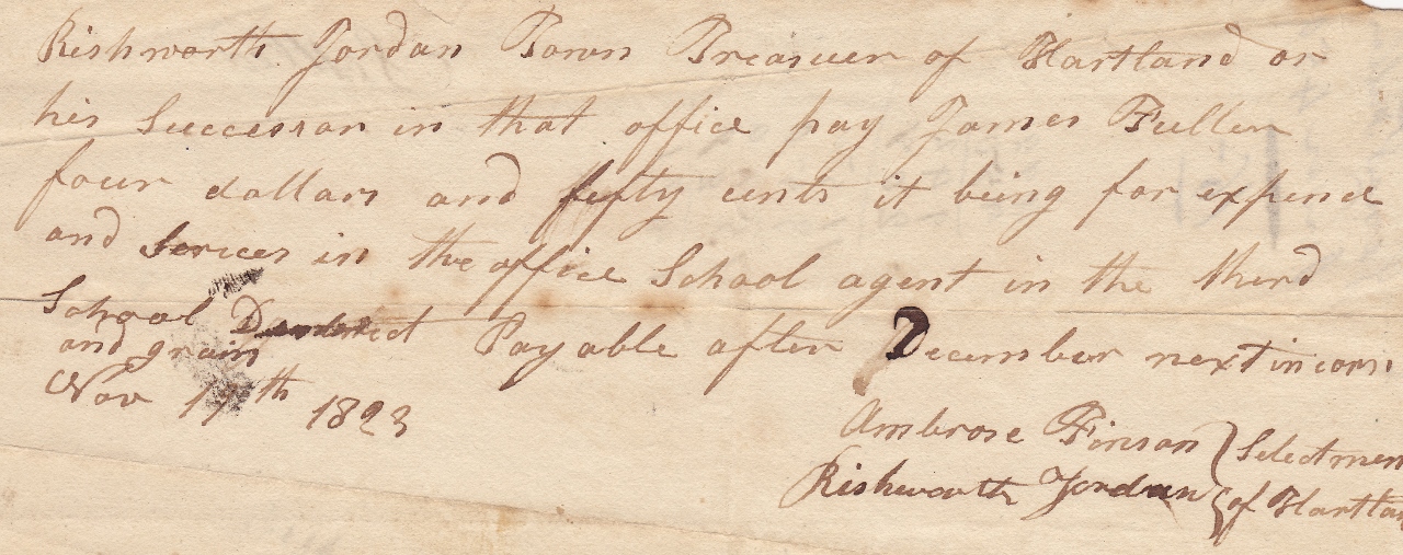
James Fuller, Sr | School Agent | November 18, 1823
*
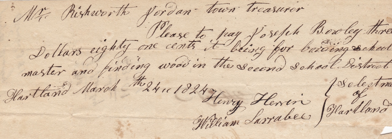
Joseph Bowley | Boarding School Master & Wood | March 24, 1824
*
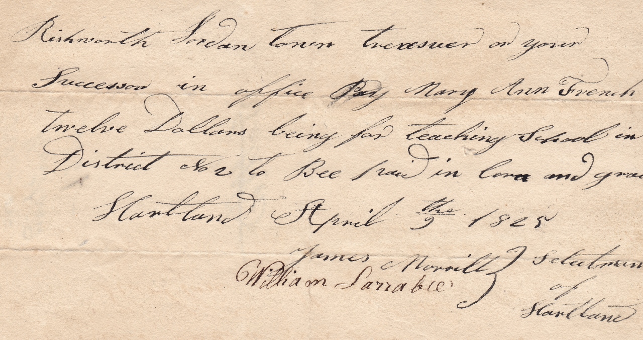
Mary Ann French | Teacher | April 9, 1825
*
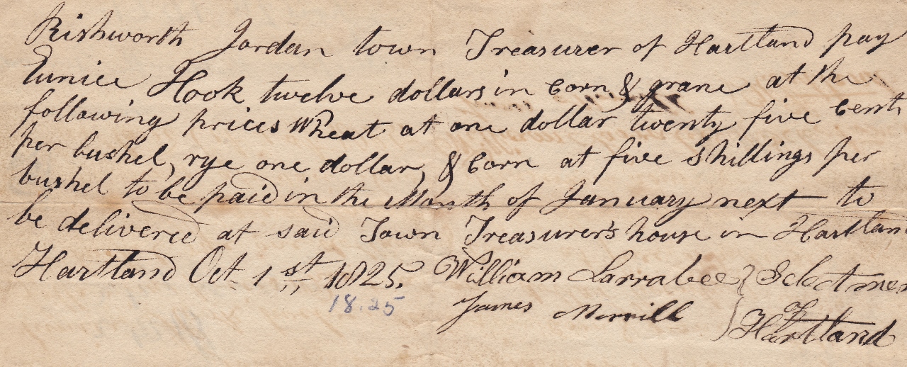
Eunice Hook | Teacher | April 9, 1825
*
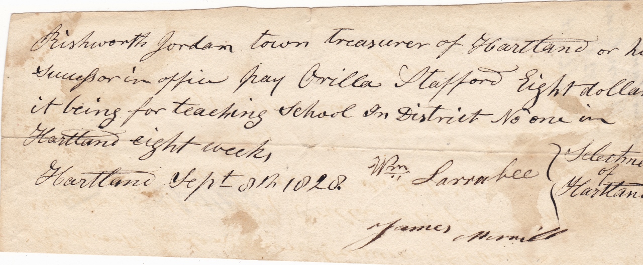
Orilla Stafford | Teacher | September 8, 1828
*
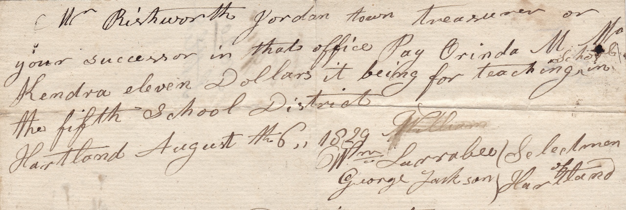
Orinda Kendra | Teacher | August 6, 1829
*
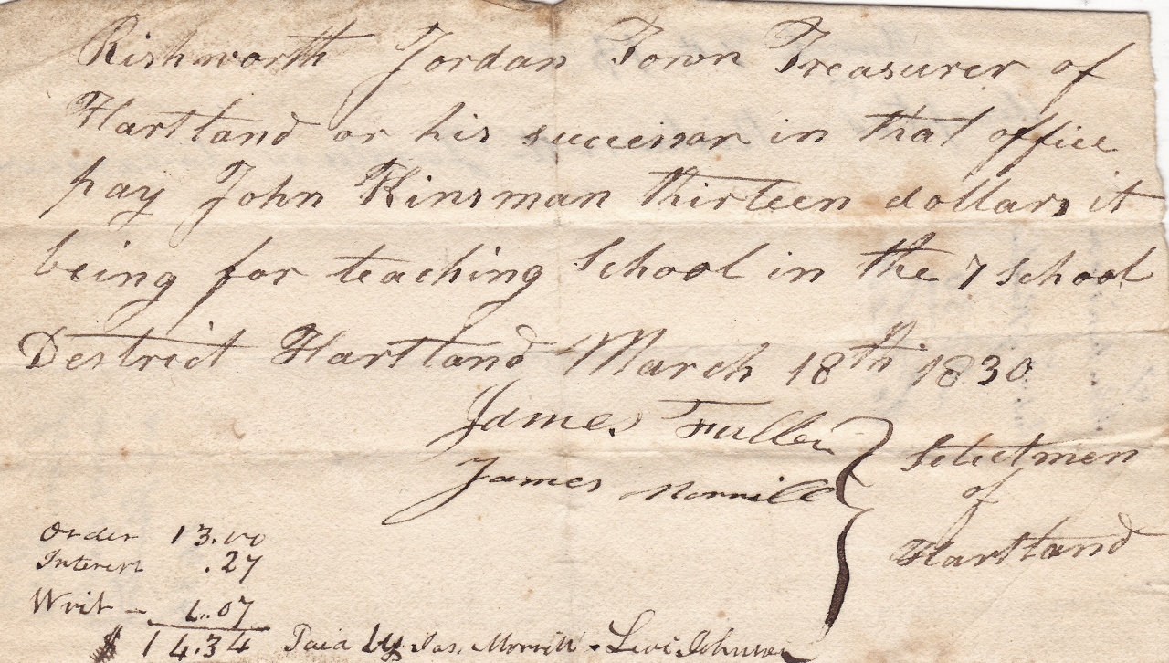
John Kinsman | Teacher | March 18, 1830
*
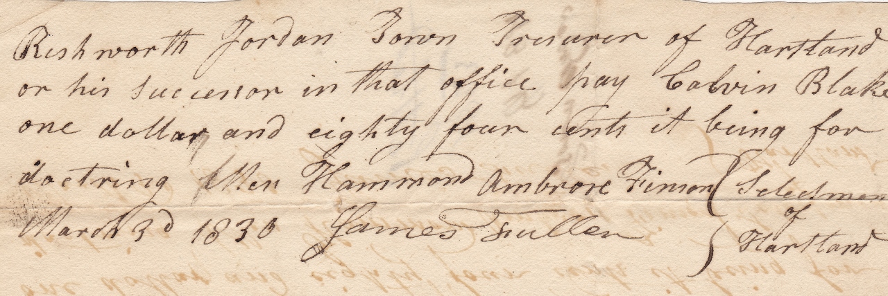
Dr. Calvin Blake | Medical Services | March 30, 1830
~ A New Hartland and St Albans Town Line – 1846 ~
The debate concerning the town line between Hartland and St Albans around the Sebasticook River area was brought up several times at Hartland Town Meetings between 1820 and 1845 until a formal petition by Hartland citizens to legally change the original boundaries was presented to the Maine State Legislature in 1846.
The petition noted the existing borders cut up the village, made it difficult to properly tax and made schooling a problem. It ended by stating the proposed line change, “Would enlarge the power of doing good, augment the facilities of business, swell the population, give spirit & vivacity, cause a union of exertion, contribute to diminish jealously, increase happiness & prosperity and produce efforts salutary and desirable.”
On August 7, 1846, the Maine State Legislature formally approved an Act to change the original Hartland and St Albans line around the Sebasticook River area to its current boundaries officially making the citizens and businesses located in that area a part of the Town of Hartland.
*
* An Act to set off a part of the Town of St Albans, and annex the same to the Town of Hartland *
Maine State Senate and House of Representatives | Chapter 384
Passed August 7, 1846
Be it enacted by the Senate and House of Representatives in Legislature assembled, as follows:
Section 1. From and after the passage of this act all that part of the Town of St Albans, in the County of Somerset, which lies west of lot numbered sixteen, in the first range of lots in said Town of St Albans, be, and is hereby set off from said Town of St Albans and annexed to the Town of Hartland in said county.
Section. 2. The Treasurer of the State is hereby authorized and directed to deduct twenty-six polls and the sum of fifteen thousand and five hundred dollars from the valuation of St Albans and annex the same to the valuation of Hartland.
Section. 3. The inhabitants on the territory aforesaid shall pay all taxes legally assessed on their polls or estates that remain due and unpaid, to the collector of St Albans; and Elizabeth E. Shean, together with all paupers having their legal settlement on the territory aforesaid, shall hereafter be supported by the Town of Hartland.
Section 4. The inhabitants of the territory aforesaid, shall have their proportion of the school money belonging to the town of St Albans, to be divided according to the number of scholars.
*
~ A New Hartland and Canaan Town Line – 1849 ~
Another large alteration to Hartland’s original boundaries ceded most of the southwest corner of West Hartland to Canaan. Many of the surviving early settlers of what had been Hartland and were active in its early town affairs then became citizens of Canaan.
*
* An Act to set off a part of the Town of Hartland, and annex the same to the Town of Canaan *
Maine State Senate and House of Representatives | Chapter 213
Passed July 17, 1849
Be it enacted by the Senate and House of Representatives in Legislature assembled, as follows:
Section 1. The following described tract of land and the inhabitants thereon and their estates, be, and the same are hereby set off from the Town of Hartland and annexed to the Town of Canaan, to wit; beginning at the southwest corner of said Hartland; thence northerly, on the west line of said Hartland to the range line between ranges two and three in said town; thence east on said range line to the east line of lot numbered thirteen in the second range; thence south on the east line of lots numbered thirteen in the second and first ranges of lots in said town to the southeast corner of lot numbered thirteen in the first range of lots in said Hartland; thence in a southerly direction to the center of the bridge across the outlet of the stream leading from Morrill Pond, so called; thence southerly down said stream until it intersects a line running due north from the northeast corner of said Canaan; thence south to the northeast corner of the said Town of Canaan; thence west on the south line of said Hartland to the place of beginning.
Section 2. The several school districts, on the territory hereby set off from said Hartland and annexed to said Canaan, shall draw their proportion of all the school money raised and assessed or to be assessed on said Hartland, and also their proportion of the bank tax for the present year, out of the treasury of said Hartland according to the number of scholars.
Section 3. The inhabitants of Canaan shall support all paupers having their legal residence on the territory hereby set off from said Hartland and annexed to said Canaan.
Section 4. All taxes assessed on the territory hereby set off as aforesaid shall be paid over to the collector of said Hartland, to be appropriated for the purposes for which said taxes were raised, for defraying the current expenses of said Hartland, for the support of the poor and for the building of reads and bridges according to the several contracts made by said town with individuals for the purposes aforesaid.
*
~ The Mysterious Land Secession – 1852 ~
One of the final town line alterations occurred on March 11, 1852 when John Warren Fuller, for reasons unknown, successfully petitioned for his West Hartland property near Fullers Corner to become part of Pittsfield. Warren (1814-1887) was the oldest child of James Fuller, Sr and was an active member in town affairs up to that point, even serving as Town Constable. In spite of several attempts to cede the lot back to Hartland over the decades, the unusual boundary line still remains in place today.
*
Alterations to its original surveyed township lines created significant changes to the boundaries on every side of Hartland by 1860.
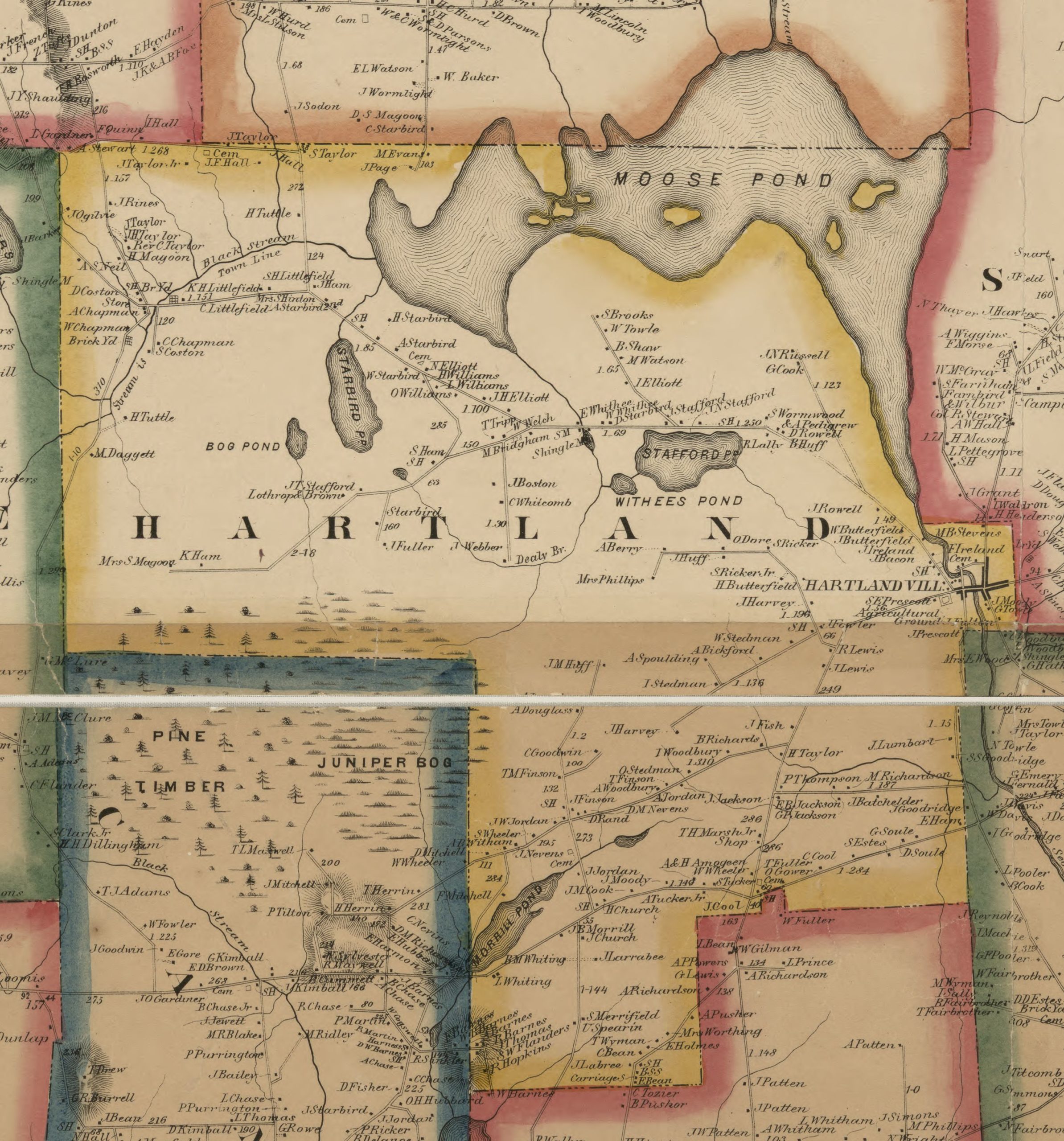
1860 Map of Hartland
Although the boundary color coding is incorrect, a notation on the map does note “Stream is Town Line” for North Hartland & Athens
*
To see a complete and enlargeable version of this original map, click the link below:
1860 Map at Library of Congress
*
~ Hartland Town Reports ~
For several decades, Warrants were posted all around Hartland with generalized information pertaining to the upcoming Town Meeting. In the early years, the initial Town Meeting was followed up by more detailed meetings to discuss and vote on specific financial appropriations per line item.
Hartland Town Meeting Warrant – 1865
*
The earliest Hartland Town Report discovered so far printed in book form is from the fiscal year ending on March 1, 1881. While only 6 pages, it included financial details for the Town Farm, Roads & Bridges, Town Officers, Schools, Miscellaneous Expenses, Liquor Agency and the assets and liabilities of the town.
New mandates for the reports were soon passed by voters as noted in the 1888-1889 Town Report, “At the last annual meeting held on March 19, 1888, the following vote was passed and accordingly the following report has been made. That the Selectmen’s Report shall be printed in full, giving each order, in favor of whom and for what purpose, also that said report shall be issued at least one week before the annual meeting.”
*
A collection of mostly post-1900 individual Hartland Town Reports may be found below at the link to the University of Maine at Orono Fogler Library website listed in .pdf format chronologically by year. Most of the Hartland Town Reports were digitally scanned for the Fogler Library Collection by Hartland Historical Society Member Ann Foss.
*
Hartland Town Report Collection
*
Hartland’s town lines were firmly established by 1883 and its total population was 1,047 people in 1880.
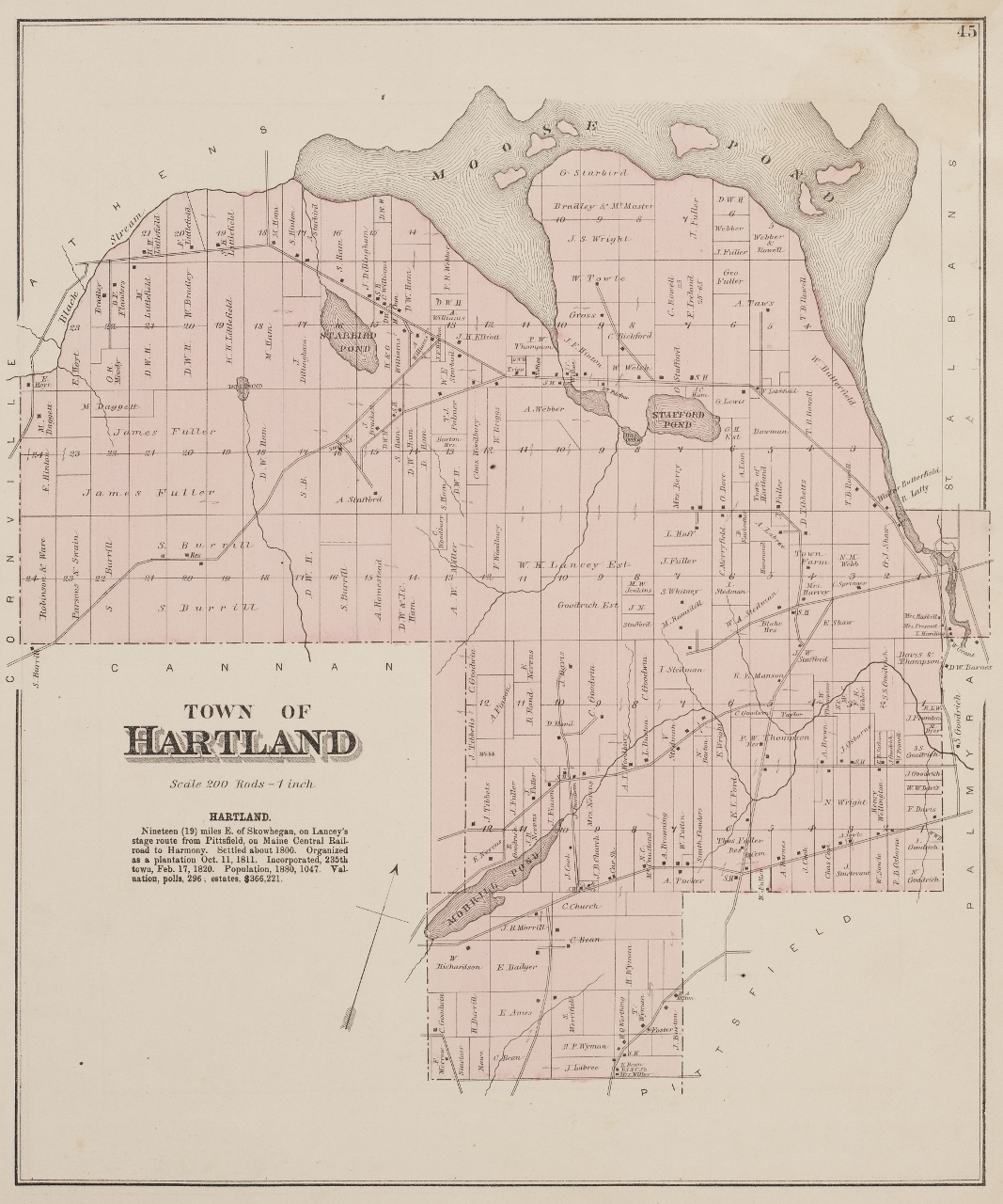
1883 Map of Hartland
*
To see an enlargeable version of this original map, click on the link below:
1883 Map at Fogler Library at UMO
*
~ A History of Hartland, Maine – 1886 ~
As written for the Gazetteer of the State of Maine by George J. Varney
Published by B. B. Russell, Boston, 1886
*
“Hartland is situated in the south-eastern part of Somerset County. St. Albans and Palmyra bound it on the east, Harmony on the north, Pittsfield and Canaan on the south, and Cornville on the west. The town is irregular in form, its greatest length, north and south, and east and west, being about 7½ miles.
The surface is very uneven, but it is without high hills. Huff Hill is the most elevated land in the town, being about 200 feet above the surrounding country. The underlying rock is chiefly granite. The soil, in parts, is clayey loam, in others sandy loam, somewhat stony, but fertile. The crops are chiefly hay, and the common variety of Maine farms.
The ponds in this town bear the names, Moose, Stafford, Morrill, Starbird, Bog and Withee. The first of these, lying on the northern and eastern border, is the largest, having an area of 12 miles. Black Stream and Sebasticook River, the outlet of Moose Pond are the largest streams.
The principal water-power of the town is on the Sebasticook River, at Hartland Village, near the eastern border of the town. There is here a factory manufacturing shawls and cassimeres, a satinet and carding factory, a grist-mill, two lumber-mills, a door, sash and blind factory, a furniture factory, two tanneries, one for sole and one for upper leather, a carriage-factory, etc. The shawl factory employs about 75 hands, and the two tanneries 50. The East Somerset Agricultural Society has for many years held its fairs in this town, where they have ample grounds and a good building.
Hartland Village is 19 miles east of Skowhegan. Pittsfield Station, on the Maine Central Railroad, 7 miles southward, is the nearest railroad connection. The stage-line from Pittsfield to Harmony runs through the town.
Hartland was formerly called Warrenstown No. 3, from Dr. John Warren, of Boston, who was the first private proprietor of the township; and from him the settlers derived their titles. The settlement was organized as a plantation in 1811 (1819), and incorporated as a town under its present name on February 17 (7), 1820.
There are Baptist, Free Baptist and Methodist societies in the town, and the first has a church edifice. Hartland Academy has furnished a good portion of the education of many prominent and successful men, and is still sustained. The number of public schoolhouses in the town is eleven and the value of the school property is $2,500.
The valuation of estates in 1870 was $264,180. In 1880 it was $366,221. The rate of taxation in the latter year was 1 and 3/10 per cent. The population in 1870 was 1,120. In 1880 it was 1,047.”
(Courtesy of Fogler Library Archives at University of Maine at Orono)
*
~ Street Names – 1897 ~
At the 1897 Town Meeting, the citizens of Hartland voted to accept an updated list of names for the existing streets in the Village. Most of the streets retained their original names at the vote, however there were a few notable exceptions.
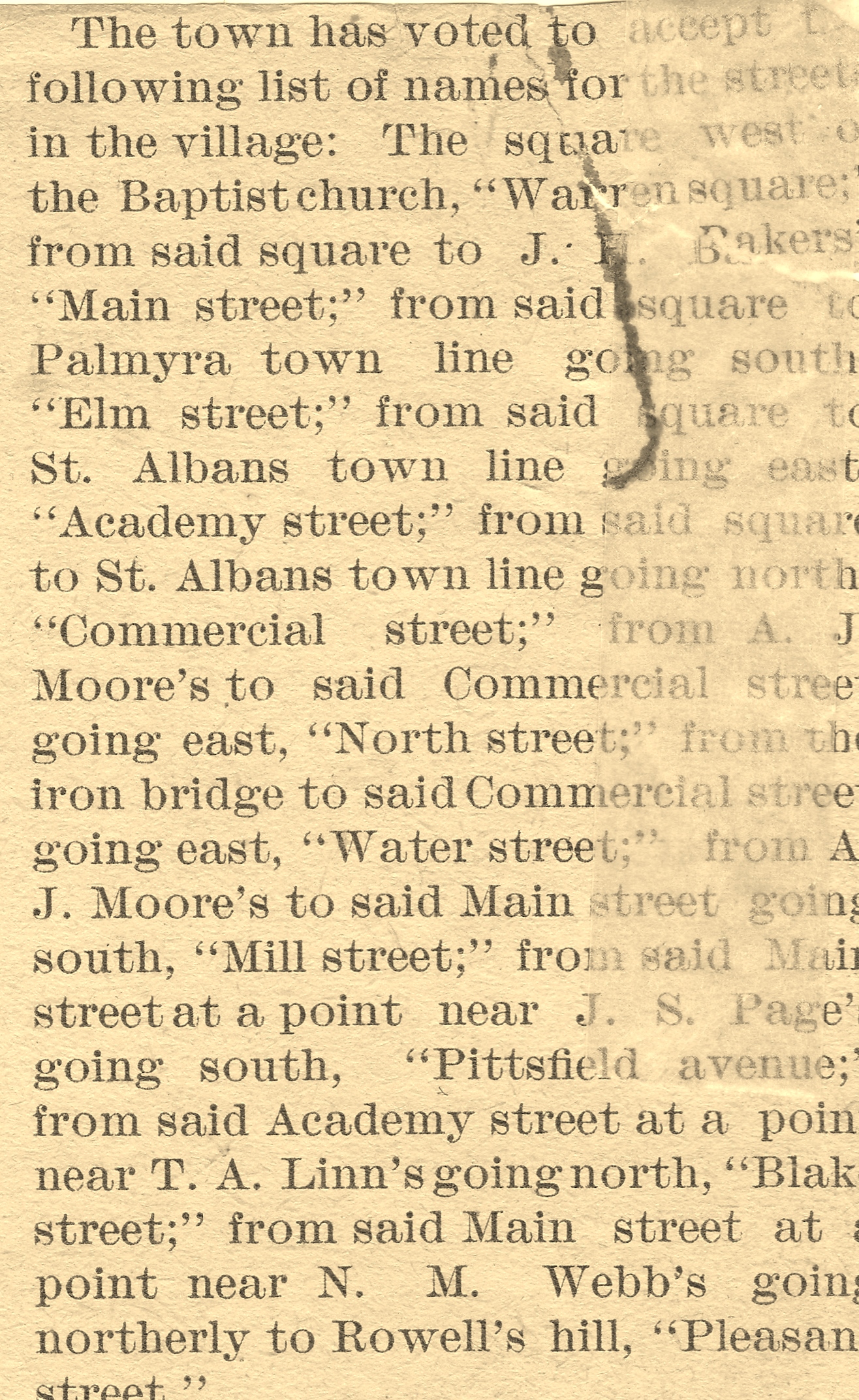
Original Street Name Article – 1897
*
The square next to the Baptist Church to be called; Warren Square
From said square to J.H. Baker’s; Main Street
From said square to the Palmyra Town Line going south; Elm Street
From said square to the St. Albans Town Line going east; Academy Street
From said Academy Street at the point of T. A. Linn’s (Thomas Archibald Linn) going north; Blake Street
From said square to the St. Albans Town Line going north; Commercial Street
From A. J. Moor’s (Amasa James Moor) to said Commercial Street going east; North Street
From the Iron Bridge to said Commercial Street going east; Water Street
From A. J. Moor’s to said Main Street going south; Mill Street
From said Main Street at the point of J. S. Page’s (John S. Page) going south; Pittsfield Avenue
From said Main Street at the point of N. M. Webb’s (Nathan M. Webb) going northerly to Rowell’s Hill; Pleasant Street
*
Street Notes
Before the changes in 1897, Commercial Street was known as North Street.
North Street was first known as Tannery Road then Billings Street after Josiah Billings built a tannery on the north side of the Upper Dam in 1856. It was later referred to by many locals as Upper Georgetown.
Water Street was known as Georgetown or Lower Georgetown. The upper section of Mill Street from the Iron Bridge to North Street was known to locals as Bridge Street.
Seekins Street did exist until 1903 when Walter E. M. Seekins first extended a new street from Commercial Street through to Blake Street which was recognized as an official street in 1910.
Moore Street was only an entry from the Mill Street side into the Moor’s various lumber mill & furniture making operations. It was extended through to Main Street by 1896 but remained a private way until 1955. It was referred to as Webb Avenue by many locals.
Hubbard Avenue was officially recognized by the town as a public street in 1958 named for Ensign S. Hubbard. It is unknown exactly when the 2 original extended driveways met to form the now familiar horseshoe avenue but for many years the two entryways were known respectively as Fairgrieve Street on the river side and Hubbard Avenue from the other side.
Crosby Street was also recognized as a street in 1958. It began as a private entry built by the Martins to their gravel pits and was named for Elwin L. Crosby, grandfather of Mike Crosby of Crosby & Neal Funeral Home.
*
~ East Somerset County Register ~
This register provides a general overview of Hartland as of 1912 including some its early settlers, businesses, churches, organizations and a listing of Town Officials beginning in 1850. A transcription of the original Hartland related pages of the book may be seen in the document below.
East Somerset County Register 1911-1912